————— NL version (ENG version below) —————
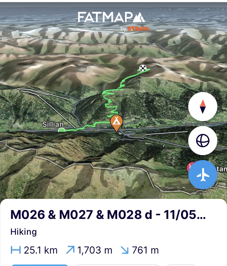
(Zaterdag 11/05) Terug op pad. De enkel die slecht ten val kwam in de Karnische Alpen ziet een beetje blauw en staat wat gezwollen maar al minder dan toen ik in Sillian aankwam. Dat komt wel goed. De bergen beslissen en aangezien het weer terug zal omslaan en ik een paar sleutelpassages door moet om naar het Höhe Tauern nationaal park te geraken, is het tijd om te gaan. Een dag voor op de planning, dus we hebben de nodige flexibiliteit onderweg. De route heb ik alvast aangepast ifv het weer en omdat ik maar zal kunnen genieten van 2 dagen goed weer loopt de route weg van hoe ze jnitieel gepland was. De schoenen die ik tot nu toe aan had, hebben (voor nu) hun diensten bewezen en zijn opgestuurd naar een halte in Sankt Moritz. Mijn alpiene schoenen lagen voor me klaar, stijgijzers ook en ik heb sneeuwschoenen weten te regelen om nog hoger te geraken in de gigantische hoeveelheid sneeuw die er dit jaar nog ligt als ook om de oude sneeuwvelden beter te baas te zijn.
Dit is het enige stuk op de totale route waarin ik van West naar Oost loop om de bergkam van de Höhe Tauern mee te pikken. Elke nieuwsgierige Oostenrijker die ik onderweg tegenkom en uitgelaten vraagt waar ik heen ga, verstaat er zich niet aan als ik zeg Monaco. Op oriëntatie kan je ze niet pakken want allen kijken ze me bedenkelijk aan en wijzen ze de andere richting aan.
Twee kleine toppen op het programma vandaag: de Glinzzipf (2126) en de Dreiheggenspitze(2368), die vooral als test dienen om te zien hoe het sneeuwpak erbij ligt op deze zuidelijk gerichte flanken. Beiden gaan zonder enig probleem en vooral op de tweede ligt er wel een significant sneeuwpak om de eerste keer de sneeuwschoenen aan te trekken. Het blijft immers sneeuwen op hoogte nadat er toen ik Slovenië doorkruiste al een serieus pak was bijgevallen. Als ik eraf moet langs de noordzijde is het niks dan natte pap sneeuw. De zware rugzak die het eten voor 9 dagen meeheeft (zoals initieel gepland) speelt met het zwaartepunt en zo ben je al gemakkelijk een kind op een glijbaan maar dan zonder het plezier ervan. Juist achter de top zet ik de tent op. Genoeg voor vandaag en de stramme enkel geeft me groot gelijk. Ik sus met 2 keer warm eten en een smeerbeurt.
https://fatmap.com/adventureid/129012337/m026-m027-m028-d-11-05-w
(Zondag 12/05) Een grote test vandaag. Nu kan ik nog rekenen op goed weer om in de volgende vallei te geraken en zo aan de grens van het nationale park. Hiervoor moet ik wel het zadel van de Regenstein (2891m) over en dus voorbij de kaap van 2750m en het sneeuwpak dat erbij komt kijken.
De nacht in de tent was geen succes door de sterke wind en de weinige slaap is in de kleren gekropen. Ik kies een oud pad om de hoogtemeters voor de dag zoveel mogelijk te beperken. Het pad definieert het concept oud of eerder vergaan. De koeien en gemzen hebben hun best gedaan om zijpaadjes aan te leggen met hun hoeven en daartussen is het pad soms spoorloos. El camino de la cabra (het pad van de geit) zoals we thuis zeggen. Ik verlies veel tijd met klauteren en heen en weer geloop en de gpx van de dag zal er niet fraai uitzien.
Nog steeds op een zuidelijke helling, begint de sneeuw echt op 2300m maar het smeltproces is in volle gang en ook hier niks dan papsneeuw waar je gemakkelijk een halve meter in zakt. Hoe hoger ik klim hoe verijsder de sneeuw maar de vorige lagen hebben serieus wat energie gekost en ik vorder zeer langzaam. Een marmot die ligt te zonnen op een steen schrikt er zelfs niet van op als ik passeer op nog geen 15 meter.
Het is 14u als ik uitgeteld op het zadel zit (2830m). Het is gelukt maar een goede les qua sneeuwkwaliteit voor de komende dagen met het oog op tochtplanning en afstanden. En nu nog naar beneden. De eerste honderden meters van de afdaling zijn serieus steil en de natte sneeuwpakken glijden oh zo gemakkelijk op de oudere hardere sneeuwlagen. Daar is het kind op de glijbaan weer en niet veel later schuift een aanzienlijk pak onder me weg. Een nieuwe stok die goed ingegraven zat in het sneeuwpak wordt gehalveerd. Dit begint me een kapitaal aan stokken te kosten. Dan maar met de ijspikkel verder.
In de zomer loopt het pad steil tegen de rotsige flanken maar alles is op deze noordelijke helling goed weg gestopt onder een wit deken. Het is secuur uitkijken op de gps naar welke flank de minste helling heeft en daar proberen door te kruipen. In het totaal witte sneeuwpak kan je immers nog moeilijk hoogteverschillen onderscheiden. Vanavond sowieso alle hellingsgraden op de route herbekijken voor de komende dagen.
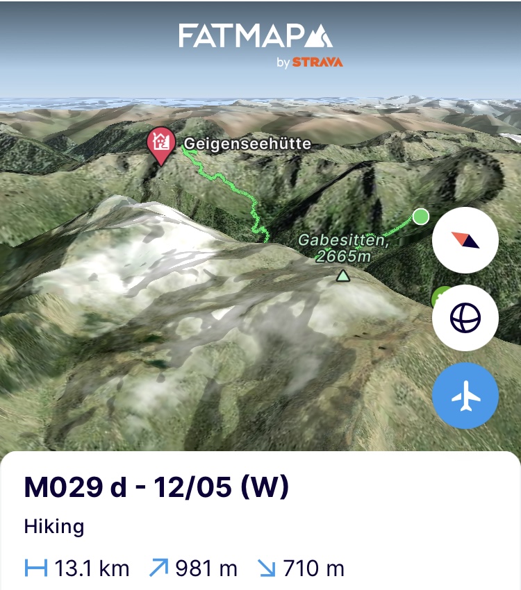
Eindpunt voor vandaag is de Geigenseehutte op 2400m. Een onbemande hut die me moet herbergen tegen de storm die voorspeld is. Niet groter dan een uit de kluiten gewassen tuinhuis maar volledig in de filosofie van de bergen. We delen onderdak voor zij die het nodig hebben. Na wat gepalaver op de sneeuwflanken kom ik aan bij de hut die nog voor de helft begraven ligt onder een twee meter dik sneeuwpak. Het bordje op de deur zegt “overnachting mogelijk, de sleutel hangt daar”. Aangezien de deur nog half ondergesneeuwd is en de architect een foutje maakte door ze naar de helling toe te laten draaien, is het eerst een kwartier sneeuwruimen met de ijsbijl tot ik de sleutel bij het sleutelgat krijg en deze parel mag bewonderen. Een zithoek, een keuken en stapelbedden. Ik ben minder gewoon hierboven. Ik installeer me en neem theepotten mee om sneeuw te gaan scheppen voor water. Hang mijn kousen en schoenen te drogen in de laatste zon, smelt sneeuw, eet twee keer warm, smeer de enkel nog eens in en ik ben klaar voor de nacht. Gezien geen bereik zullen de felicitaties voor moederdag even moeten wachten. Morgen eerste taak in de vallei.
https://fatmap.com/adventureid/129012425/m029-d-12-05-w
(Maandag 13/05) Een maand onderweg. Het laatste ijzertablet van de kuur die ik moest volgen herinnert me er ‘s ochtends aan. Het leek nog steeds alsof ik gisteren pas vertrok. Teken dat we ons amuseren, zeggen we dan. De zware storm die voorspeld was, is uitgebleven maar ‘s nachts heeft het wel goed gehageld. Vandaag ziet het er momenteel aan de lucht te zien ook nog OK uit maar in de bergen kan je nooit 100% zeker zijn. Preventief gaat de rugzak naar regenstand om alles wat zeker niet nat mag worden op de juiste plaats te steken en er een hoes over te trekken. Ik laat de hut achter zoals ik ze vond en begin de afdaling naar de vallei. Om 7u vertrek ik en probeer ik zoveel mogelijk de bevroren sneeuw te gebruiken om snel te vorderen. Maar ook hier loopt het zomerpad aangenaam tegen de steile rotsflanken en is het in deze condities niet opportuun. Dan maar zoeken en doen om mijn helling en afdaling te vinden en dat verloopt pittig.
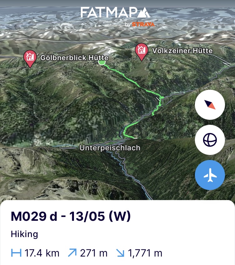
Beneden in de vallei aangekomen, strand ik in het bergdorpje Hopfgarten in Deferregen. Een klein pittoresk iets dat spijtig genoeg geplaagd wordt door erosie van de bergflanken en lawines. Die laatste zijn niet niet alleen een gevolg van een minder permanent sneeuwdek en dus acutere regenval maar eveneens van minder bomen om de neerslag op te vangen. In de vorige blog beschreef ik de plaag van de schorskever al die steeds meer bossen aantast en bomen doodt. Die dode bomen kunnen de functie van een boom niet opnemen waarin ie niet alleen water opvangt via bladeren, takken en stam maar ook de bodem stabiliseert en er de waterbalans op peil houdt. Gevolg het water en steeds vaker de regenval heeft vrijspel op de hellingen met lawines en aardverschuivingen als gevolg. Het dorpje staat alvast voor zware investeringen om lawinebrekers en rivierbeddingen te (her-)aanleggen.
Ik zet de route voort via het 2-talerpad tot in de volgende vallei om daar te stranden in Huben en de tocht de volgende dag verder te zetten naar Sankt Johan im Walde. Het onweer is opgeschoven met 2 dagen, dus ik moet de routes sowieso nog eens tegen het licht houden. De bergen, ze houden je alvast permanent bezig. Maar eerst Moederdag felicitaties de wereld in sturen.
https://fatmap.com/adventureid/128264511/m029-d-13-05-w
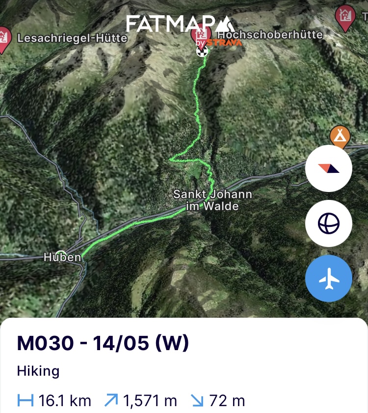
(Dinsdag 14/05) Vanuit Huben volg ik de Isel rivier stroomafwaarts die naast me kolkt van al het smeltwater dat ze moet afvoeren. In het volgende dorp, Sankt Johan im Walde, steek ik de flank van een zij-vallei omhoog richting de Hochschober hütte. Nog 10 kilometer te gaan en 1500 hoogtemeters voor de dag te bedwingen. De weg naar boven is pittig maar 3 uur later zijn ze eraan. Onderweg is er niks dan opluchting als ik zie hoe het sneeuwpak er hier bij ligt. Op 2000m niks. Op 2100m niks. Op 2200m flarden oude sneeuw. Op 2300m, net onder de hut, stervende sneeuwvelden die verspreid liggen als gemorste melk.
De hut en het winterruim zijn volledig sneeuwvrij. Als ik de route van morgen zie, dan ligt die er eveneens prachtig bij. Morgen wordt echter pittig want ik moet 2 keer een zadel door op 2700m maar met wat ik nu zie, is het hoopgevend. De noordelijke hellingen die erachter liggen, zijn problemen die we dan wel oplossen maar de steilheid ervan valt beter mee dan eerder. Nu installeren in het winterruim, opdrogen in het zonnetje, eten, slapen en morgen vroeg aan de bak.
https://fatmap.com/adventureid/129012468/m030-14-05-w
(Woensdag 15/05)
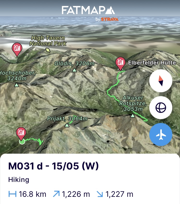
Om 7u begin ik eraan. Met 1100 hoogtemeters in de sneeuw heb ik meer dan voldoende voor de boeg vandaag. Daarenboven zal het heel de dag bewolkt zijn en ligt het wolkendek als ik opsta zo’n 100m boven me. Qua zichtbaarheid gaat dat dus dik tegensteken. Het eerste zadel ligt op 2km van de hut en ik heb er maar liefst 1,5u de tijd voor nodig om er te geraken. In de afdaling erachter schuift het natte sneeuwpak als niks. Na wat uitschuivers geraak ik op minder hellend terrein en gaat het marcheren met de sneeuwschoenen vlotter tot aan de Lienzer hütte waar ze alles in gereedheid aan het brengen zijn voor de start van het nieuwe bergseizoen.
Laat dat nieuwe bergseizoen maar snel starten, heb ik me al vaak bedacht. Vorige winter zagen de Alpen bijzonder weinig sneeuw en dit jaar blijft het maar sneeuwen op hoogte. Het ploeteren door de oude papsneeuw met hier en daar verse lagen bovenop weegt toch serieus door op de fysiek. De hut is niet het eindpunt voor vandaag. Eerst moet ik nog een tweede zadel over tot aan de Elberfelder hütte. Ik probeer zo lang mogelijk het aandoen van de sneeuwschoenen uit te stellen om snelheid te kunnen maken maar op 2350m is er geen doorkomen meer aan. Als extraatje smijt het wolkendek zich ook nog eens volledig dicht en daalt de zichtbaarheid naar iets van een vijf meter. Een laatste steenmannetje tegen een ondoorzichtige witte achtergrond wijst me nog een laatste keer de weg. En het betert er niet op. Op sommige momenten gaat de zichtbaarheid naar juist de punten van mijn sneeuwschoenen. Een totale white-out. Niet ideaal maar het heeft wel iets magisch en beklemmend tegelijk.
Navigeren wordt een processie van 25 stappen zetten en opnieuw koers bepalen met de gps op het horloge. Die laatste durft nog al eens tilt slaan tussen de hoge bergflanken met als resultaat een traject alsof ik iets kwijt zou zijn en 1000 maal op mijn stappen terugkeer. De gps op de telefoon en tracker worden ook bovengehaald om de vorige te controleren en bij te staan. Tot aan het zadel zie ik niks. Vraag me dus zeker niet hoe mooi dit deel van het nationaal park is want ik zou het je niet kunnen zeggen.
De afdaling is milder en de sneeuw is van een veel betere kwaliteit. De regen die de kop heeft opgestoken deert me dus niet. Pas als ik in het winterruim van de Elberfelder Hütte aankom valt me op hoe doorweekt ik ben. Tot nu toe waren de winterruimen van de hutten zeer sober maar deze is van een andere orde. Propere stapelbedden en een houtkachel. Alle kleren gaan uit. De stoof gaat aan. Droge kleren aan. Een soepketel sneeuw halen buiten en laten smelten op de kachel. In een mum van tijd stook ik heel het ruim warm en hangen al mijn kleren als wellustige toeschouwers rond de kachel. Ik bekijk de route voor morgen die me naar een nieuwe kaap van 2950m moet brengen maar gelukkig in beter weer zal verlopen. Ik pas ze aan volgens hoe de sneeuwflanken erbij liggen en laat het rusten tot morgen. Nu opwarmen, eten, enkel smeren. slapen en morgen naar het eindpunt.
https://fatmap.com/adventureid/129012528/m031-d-15-05-w
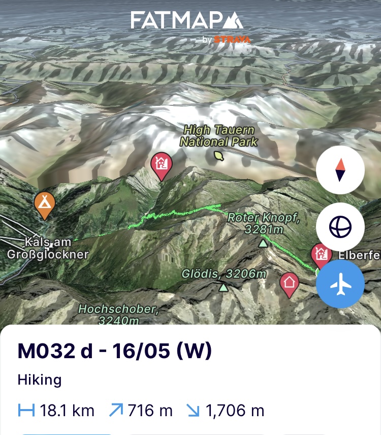
(Donderdag 16/05) De opklaringen die voorspeld waren, blijven alvast uit. De hut en de bergen errond liggen in een dik wolkenpak. Niks aan te doen we moeten er door. De route naar de Kesselkeesattel (2980m) loopt steil tegen de bergflank op maar in deze wintercondities ben je daar niks mee. De meest aangewezen routes zijn de waterlopen. Ze snijden de vallei uit en dus het laagste punt dat zonder watervallen in acht te nemen zich dus als een slang naar beneden laat glijden. Door de grote hoeveelheid sneeuw ligt er een dik pak bovenop de rivier en kan je er gemakkelijk over. De sneeuw daarenboven vertekent het landschap totaal en de hoogtelijnen op je kaart zijn vaak niks meer waard daar waar wind en sneeuw hun eigen plantsoen hebben aangelegd.
Ik schuifel dus als een slang in zigzagbochten de vallei naar boven in. Voortdurend de evaluatie makend of er in dit hertekend kader een betere weg zou zijn die nog energie-efficiënter is. Na 3u slingeren in het sneeuwpak kom ik bij het zadel van de dag aan. De laatste 100m tot in het zadel hebben toch een helling van 50 à 55 graden in dit sneeuwdek. Ik traverseer dus de volledige bergkom om geleidelijk aan hoogte te winnen en zo dicht mogelijk onder het zadel te geraken. Als ik net onder het zadel een verijsde sneeuwlaag tegenkom, maakt de slang een laatste bocht. De ijsbijlen die ik al binnen handbereik had, komen boven en ik houw me een weg door de ijslaag tot aan het zadel. Naast een noodbivak staat er ook de typische gele wegwijzer die toeristen in de zomer veilig door de bergen loodst maar in deze condities heb je daar niet veel aan. Erop is gemakkelijk. Eraf is de uitdaging. Gelukkig is er vorige nacht nog 30cm verse sneeuw bijgevallen en die plakt goed. De afdaling is dus recht naar beneden de volgende vallei in. Hier en daar wat schuifwerk maar alles blijft zeer mooi liggen en ik blijf voor een keer recht.
De afdaling is lang en ook beneden maak ik nog eens gebruik van een kleine vallei uitgesneden door een stroompje. Op 2350m gaan de sneeuwschoenen uit en is het verder het bergpad volgen tot in Kals am Grossglockner. In het dorp val ik binnen bij Claudia die al een maand op proviand en alpiene materiaal aan het passen is sinds ik het er heb afgezet op mijn weg naar het startpunt van deze tocht. Ze slaakt een zucht van opluchting als ze me de deur ziet binnen wandelen terwijl ze vertelt wat voor een slecht weer het wel niet is geweest de voorbije weken. Ik kan er van mee spreken. Ongelofelijk gastvrij als ze is, stelt ze onmiddellijk voor om mijn kleren te wassen. Ik kijk vooral uit naar mezelf te wassen…en…
https://fatmap.com/adventureid/129012574/m032-d-16-05-w
Op naar Monaco!
Bergse groeten en tot snel!
————— ENGLISH VERSION —————
(Saturday 11/05) Back on the route. The ankle that had a bad fall in the Carnic Alps looks a bit blue and is a bit swollen, but less than when I arrived in Sillian. It will be alright. The mountains decide and since the weather will turn bad again in a few days and I have to cross a few key passages to get to the Höhe Tauern National Park, it's time to go. One day ahead of schedule so I have the necessary flexibility along the way. I have already adjusted the route based on the weather forecasts and because I will only be able to enjoy 2 days of good weather, the route is moving away from how it was initially planned. The shoes I was wearing so far have served their purpose (for now) and have been sent to a stop in Sankt Moritz. My alpine boots were waiting for me, crampons too and I managed to get snowshoes to get even higher in the enormous amount of snow that is still there this time of the year and also to better manage the old snow fields.
This is the only part of the entire route in which I will walk from West to East to reach the ridge of the Höhe Tauern. Every curious Austrian I meet along the way who cheerfully asks where I'm going, is struck by confusion when I say Monaco. You can't catch them on orientation because they all look at me doubtfully and point in the other direction.
On the program today are 2 small peaks, the Glinzzipf (2126) and the Dreiheggenspitze (2368), which mainly serve as a test to see what the snowpack is like on these south-facing flanks. Both pass without any problem and especially on the second one there is a significant amount of snow to put on the snowshoes for the first time. The massive snowfall I witnessed when crossing Slovenia, has also struck here and it keeps on snowing above 2500m. When I need to descent on the north side of the summit, it's nothing but wet, muddy snow. The heavy backpack which contains food for 9 days (as initially planned) plays with the center of gravity and I easily become the kid on slide of the playground, but without the fun. Just behind the summit I pitch my tent. Enough for today and the stiff ankle couldn’t agree more. I soothe it with 2 servings of hot food and a muscle cream.
https://fatmap.com/adventureid/129012337/m026-m027-m028-d-11-05-w
(Sunday 12/05) A big test today in good conditions since I still have a day of good weather ahead of me to get to the next valley and thus to the border of the national park. For this I have to cross the saddle of the Regenstein (2891m) and therefore pass the milestone of 2750m in altitude and the snowpack that comes with it.
The night in the tent was not a success due to the strong wind and the little sleep I had. I choose an old path to limit the elevation gain for the day as much as possible. The path defines the concept of old. The chamois and cows have done their best to build side paths with their hooves making me lose the initial path easily. El camino de la cabra (the path of the goat) as we say at home. I lose a lot of time climbing and walking back and forth to stay on it. The GPX of the day will not look nice.
Still on a southern slope, the snowpack starts at 2300m, but the melting process is in full motion and here too nothing but slushy snow into which you can easily sink half a meter. The higher I climb, the more icy the snow becomes, but the previous snow packs took some serious energy out of me and I am making very slow progress. A marmot sunbathing on a stone doesn't even startle when I pass at less than 15 meters.
It's 2pm when I'm sitting on the saddle (2830m), but it's a good reality check in terms of snow quality for the coming days and how to cope with it in route planning and distances. And now down. The first few hundred meters of the descent are seriously steep and the wet snowpacks slide oh so easily on the older harder snow layers. There's the child on the slide again and not much later a large package slides away from under me. A new stick that was well buried in the snowpack is halved. This is starting to cost me a fortune in sticks. So continuing with the ice axe.
In summer the path runs steeply against the rocky flanks, but everything on this northern slope is well hidden under a white blanket. You have to carefully look at the GPS to see which flank has the least gradient and try to crawl through there. Adjacently, it is hard to distinguish height differences in the completely white snowsuit. Tonight, I will definitely reassess the gradient of all slopes on the route for the coming days.
The end point for today is the Geigenseehutte at 2400m. An unmanned hut to shelter me against the predicted storm. No bigger than an oversized garden house, but completely in line with the philosophy of the mountains. We share shelter for those who need it. After some craziness on the snow slopes I arrive at the hut, which is still half buried under a two-meter thick snowpack. The sign on the door says “overnight stay possible, the key is hanging over there.” Since the door is still half covered in snow and the architect made a mistake by having it turning towards the slope instead of away from it, it takes fifteen minutes of clearing snow with the ice ax before I get the key to the keyhole and can admire this pearl. A sitting area, a kitchen and bunk beds. I'm used to way less up here. I settle in and take teapots with me to shovel snow for water. Hang my socks and shoes to dry in the last sun beams, melt the snow, eat twice, take care of the ankle again and I'm done for the night. Since there is no reach, congratulations for Mother's Day will have to wait a while. First task in the valley tomorrow.
https://fatmap.com/adventureid/129012425/m029-d-12-05-w
(Monday 13/05) A month on the road. The last iron tablet of the treatment I had to take reminds me in the morning. It still seemed like I only left yesterday. Sign that we are having fun. The heavy storm that was predicted, did not materialize, but it did hail heavily during the night. Today the sky looks OK, but in the mountains you can never be 100% sure. As a preventive measure, the backpack goes into rain mode to put everything that should definitely not get wet in the right place and put a cover over it. I leave the hut as I found it and start the descent into the valley. I leave at 7am and try to use the frozen snow as much as possible to make quick progress. But here as well, the summer path runs pleasantly against the steep rock flanks and is not an option in these conditions. Then I just have to search my ideal slope and descent which is going to be tough.
When I arrive at the bottom of the valley, I plant myself in the mountain village of Hopfgarten in Deferregen. A small picturesque thing that is unfortunately plagued by erosion of the mountain flanks and avalanches. The latter are not only a result of less permanent snow cover and therefore more acute rainfall, but also of fewer trees to absorb the precipitation. In the previous blog I described the plague of the bark beetle that is affecting more and more forests and killing trees. These dead trees cannot perform the function of a tree in which it not only collects water through leaves, branches and trunk, but also stabilizes the soil and maintains the water balance. As a result, the water and increasing rainfall has free rein on the slopes, resulting in avalanches and landslides. The village is already facing heavy investments to (re)construct avalanche breakers and riverbeds.
I continue the route via the 2-taler path to the next valley to end up in Huben and continue the tour the next day to Sankt Johan im Walde. The thunderstorm has moved up by 2 days, so I will have to re-examine the routes anyway. The mountains keep you busy all the time. But first send Mother's Day congratulations to the world.
https://fatmap.com/adventureid/128264511/m029-d-13-05-w
(Tuesday 14/05) From Huben I follow the Isel river downstream, which is swirling next to me with all the meltwater that it has to drain. In the next village, Sankt Johan im Walde, I start my climb to the Hochschober hütte in a side valley. Still 10 kilometers to go and 1500 meters of altitude to conquer for the day. The way up is tough, but 3 hours later I arrive. Along the way there is nothing but relief when I see what the snowpack looks like here. Nothing at 2000m. Nothing at 2100m. Patches of old snow at 2200m. At 2300m, just below the hut, dying snow fields scattered like spilled milk.
The hut and the winter bivouac are completely free of snow. When I see tomorrow's route, it also looks in good conditions. However, tomorrow will be tough because I have to go through two saddles at 2700m meaning climbing and descending twice. But with what I see now, it is hopeful. The northern slopes behind those saddles are problems that we will solve when they occur but their steepness is less than what I encountered before. Installing in the winter bivouac, dry up in the sun, eat, sleep and start early tomorrow.
https://fatmap.com/adventureid/129012468/m030-14-05-w
(Wednesday 15/05)
I start at 7am. With 1100 meters of altitude gain in the snow, I have more than enough to do today. In addition, it will be cloudy all day. When I get up the cloud cover is only 100m above me. In terms of visibility, this is a major disadvantage. The first saddle is 2km from the hut and it takes me no less than 1.5 hours to get there. In the descent behind it, the wet snowpack slides way too easily. After a few slips I reach less steep terrain and the marching with snowshoes goes more smoothly to the Lienzer hütte where they are preparing everything for the start of the new mountain season.
Let the new mountain season start soon, I have often thought. Last winter the Alps saw very little snow and this year it keeps snowing in the high mountainside. The hut is not the end point for today. First I have to cross a second saddle to the Elberfelder hütte. I try to postpone putting on the snowshoes for as long as possible in order to gain speed, but at 2350m there is no way to get through. As an extra, the cloud cover also completely closes and visibility drops to something like five meters. A last cairn against an opaque white background shows me the way one last time. And it's not getting any better. At times the visibility goes to the very tips of my snowshoes. A total whiteout. Not ideal, but it does have something magical and oppressive at the same time.
Navigating becomes a procession of 25 steps and re-charting course with the GPS on the watch. The latter sometimes dares to tilt between the high mountain flanks, resulting in a trajectory as if I had lost something and had to retrace my steps 1000 times. The GPS on the phone and tracker are also brought out to check and assist the previous one. I can't see anything up to the saddle. So don't ask me how beautiful this part of the national park is because I couldn't tell you.
The descent is gentler and the snow is of much better quality. When it starts to rain it doesn’t even bother me. Only when I arrive in the winter bivouac of the Elberfelder Hütte I notice how soaked I am. Until now, the winter bivouacs of the huts (which are still closed pre-season) have been very simple. But this is of a different order. Clean bunk beds and a wood stove. All clothes come off. The stove turns on. Put on dry clothes. Get a soup kettle of snow outside and let it melt on the stove. In no time I heat up the entire bivouac and all my clothes are hanging around the stove like lustful spectators. I look at the route for tomorrow, which should take me to a new milestone of 2950m, but fortunately it will take place in better weather. I adjust them according to the mountain slopes and leave it alone until tomorrow. Now get warm, eat, sleep and repeat.
https://fatmap.com/adventureid/129012528/m031-d-15-05-w
(Thursday 16/05) The better weather that was predicted has not materialized. The hut and the mountains around it are covered in thick clouds. Nothing can be done about it, I have to get through it. The route to the Kesselkeesattel (2980m) runs steeply up the mountainside, but in these winter conditions that is of no use. The most recommended routes are the waterways. They cut out the valley and therefore are the lowest and flattest point sliding down the mountains like a snake (without taking waterfalls into account). Due to the large amount of snow, there is a thick layer on top of the river and you can easily cross it. In addition, the snow completely distorts the landscape and the contour lines on your map are often worthless since wind and snow have created their own map.
So I shuffle like a snake in zigzag turns up into the valley. Constantly evaluating whether there would be a better way which is even more energy efficient. After 3 hours of swinging in the snowpack I arrive at the saddle. The last 100m to the saddle have a slope of 50 to 55 degrees. So I traverse the entire valley range to gradually gain height and get as close to the saddle as possible. When I encounter a layer of icy snow just under the saddle, the snake makes a final turn. The ice axes that I already had within reach emerge and I cut my way through the ice layer to the saddle. In addition to an emergency bivouac, there is also the typical yellow signpost that guides tourists safely through the mountains in the summer, but in these conditions it is of little use.Fortunately, 30 cm of fresh snow fell last night and it is sticking well. So the descent is straight down into the next valley. Some sliding here and there, but everything stays in place very nicely and for once I stay up straight.
The descent is long and at 2350m I take off the snowshoes and continue following the mountain path to the endpoint of this stage in Kals am Grossglockner. In the village I arrive at Claudia’s place who has been looking after provisions and alpine equipment for a month since I dropped it off on my way to the starting point of this tour. She expresses a sigh of relief when she sees me walk through the door while she tells me how bad the weather has been in recent weeks. I can speak to that. Incredibly hospitable as she is, she immediately suggests washing my clothes. I'm especially looking forward to washing myself…and…
https://fatmap.com/adventureid/129012574/m032-d-16-05-w
Off to Monaco!
Mountain greetings and see you soon!Start hier met schrijven...
