meer foto's op fatmap (zie link in tekst)
————— NL version (ENG version below) —————
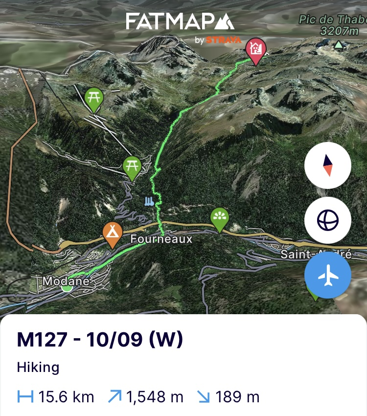
(Dinsdag 10/09) Rustdagen mag ik ze niet meer noemen. Altijd wel iets om handen. Eten kopen voor de volgende etappe, gaspatronen zoeken, rustplaatsen herboeken, wassen, scheren, mails beantwoorden, thuisfront bellen, een interview voor een magazine, enz. Een dagje rust is dus snel om. Misschien moet ik ze schransdagen noemen. Je kan je niet voorstellen wat ik binnenspeel op zo’n dag. 3 zakken chips, chocolade, 2 zakken snoep, halve kilo druiven, 4 bananen, halve kilo blauwe bessen, 4 liter frisdrank, … en dan heb ik het ochtend- en avondeten nog niet meegeteld. Het lichaam heeft er alvast van genoten en voelt terug volledig top. Desalniettemin start ik de etappe op mijn dooie gemak. Ik ben de horloge vergeten opladen, dus doe ik dat eerst terwijl ik het nieuws lees. Om 9u zak ik terug af naar het dorpsplein waar ik de vorige etappe stopte en zet me op het terras voor koffie. Koffie op en ik begin eraan. Deel 17 van de tocht.
Ver loop ik niet want een kilometer verderop is een bakkerij, dus stoppen voor meer koffie en croissants. Zoals ik zei, op mijn dooie gemak. Tegen 11u komt de zon er goed door en gaat de etappe echt van start. Ver ga ik niet vandaag. Slechts 15km en 1500 hoogtemeters. De patella-pees in mijn linkerknie deed gisteren en op de laatste dag van de vorige etappe lastig. Even kalm aan doen dus zodat we zeker in Monaco geraken. Ik laat het triestige Modane achter me en trek een vallei in, die er haaks op uitkomt, naar boven. Op naar het nationaal park Les Écrins.
De route voor vandaag loopt de volle 15km in stijgende lijn langs de GR5. De benen zijn onstuimig en aan een hoog tempo gaan de eerste 500 hoogtemeters er door. Ik zet me bijna een uur in de zon om de blok er wat op te houden. Maar als ik terug start, gaan de resterende 1000 hoogtemeters er in een even snel tempo aan. Het pad waar ondertussen de via alpina ook aansluit, is ook niet het mooiste en leent zich tot kilometers stampen. Pas als het overgaat in de GR57 die hier rond de Mont Thabor (3178m) loopt, kom ik aan de Col de la Vallée-Étroite (2438m) en de prachtige vallei Vallon du Peyron en de rotswand die ze omhult. Nog een stuk verder en de dag zit erop. In een steenkring naast het pad waar al eens tenten hebben gestaan, zet ik de mijne op. Het is 3u. Nog wat genieten van de zon, eten, schrijven en op tijd het bed in. Morgen iets meer maar ook niet te veel, de pees in gedachten. Als ik bijna aan het indommelen ben en het bijna pikdonker is buiten, word ik gewekt door 3 Italianen op sportschoenen. Ze moeten naar de hut die 3km terug ligt maar hebben geen idee hoe. Een van hen laat me op zijn telefoon op Google maps zien waar ze waren uitgekomen en vraagt me om aan te duiden waar de hut exact ligt. Een tip: met Google maps ben je niks in de bergen. Paden staan er niet op en hutten ook niet altijd. Gelukkig ligt de hut naast een meer en dat vind ik wel terug op zijn telefoon. Maar de paniek zit er in bij het gezelschap aangezien ze ook geen hoofdlampen hebben om het pad te kunnen volgen. Na veel vijven en zessen, kruip ik uit mijn slaapzak en zeg ik hen dat ik hen halverwege op het pad zal afzetten. Een algehele zucht van Italiaanse opluchting. Italianen en topografie, het blijft toch een tang op een varken. Kleren aan, ik mijn hoofdlamp aan en zij het licht op hun telefoons en we trekken het donker in. Onderweg geef ik hen aan hoe ze het pad kunnen herkennen en waar ze markeringen kunnen terugvinden. Wanneer de meest onduidelijke passage in het pad achter de rug is, neem ik afscheid en geef ze nog ‘high level’ een idee hoe de rest van het pad loopt. Enkele ‘mille grazies’ later ben ik terug op weg naar mijn dons. En nu slapen.
https://fatmap.com/adventureid/158202757/m127-10-09-w
(Woensdag 11/09) Het heeft gevroren en dat was eraan te voelen. De neus die soms ‘s nachts ongewild vanuit de slaapzak kwam piepen, heeft me een paar keer wakker gekregen. Geen havermout dus deze ochtend want die zou intussen bevroren zijn geweest. Dan maar de overtollige repen opeten en starten aan de klim. Ik hoop dat het Italiaans gezelschap van gisteren de hut heeft gevonden want een nacht in deze koude buiten is geen lachertje. Voor mezelf een rustige dag vandaag met vooral een klim aan de start van de route tot net onder Mont Thabor (3178m) via de GR57. De vallei beneden ligt nog in een dik wolkentapijt maar hier boven komt de zon er al door.
Eens onder de top buigt het pad tegen een helling in verschillende steenlagen en -kleuren richting nationaal park. In de verte prijken de 2 4000m+ toppen van het park al tegen de horizon. De Barres des Ecrins (4102m) en Dôme de neige des Ecrins (4015m). De initiële route heb ik een stuk moeten aanpassen want de routes voor de andere toppen om over te steken, liggen er te slecht bij. Het park doorkruisen is geen evidentie aangezien de bergwanden zeer steil zijn en je snel in alpiene terrein en routes zit. We zullen dus binnen een paar dagen proberen om ze via de zuidkant te beklimmen. Maar eerst hier verder richting Roche du Chardonnet (2950m) via de graat die er heen loopt. In mijn onmetelijke voorkeur om graten te doen, kruip ik te vroeg de graat op, daar waar het pad eerst de flank volgt. Na 2 steenbokken te hebben opgeschrikt, zit er niks anders op dan een stuk van de steile bergflank af te klimmen naar beneden. Moest ons moeder het zien, ze bond me vast aan de poot van de keukentafel.
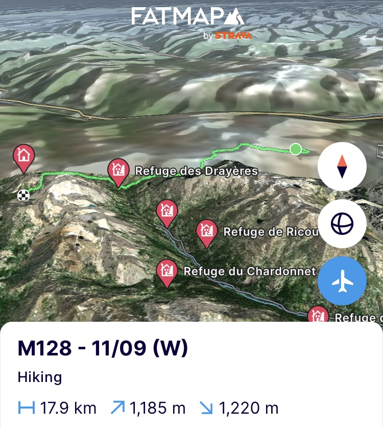
Veilig en wel terug op het pad moet ik door het rotspuin om een stuk verder op de graat terecht te komen en die te volgen richting top. Een geweldig zicht van hieruit op het nationaal park en zijn besneeuwde bergtoppen. Uit de wind op de top is het rusten met het 4G signaal dat ik vond. Snel wat zaken bekijken en opvolgen en dan naar beneden langs de vele wandelaars die de GR57 hier volgen. Beneden aan de Refuge de Drayères is het pauzeren voor suikers en opladen van de telefoon. Het weer zal rond 16u omslaan, er komt regen voor de rest van de dag. De regenhoes gaat dus over de rugzak en ik trek verder op de resterende 9km voor vandaag.
In de Col des Cerces (2574m) is het manoeuvreren en wachten tussen wel 2000 schapen die de pas oversteken. Als de laatste er door zijn, dender ik naar beneden. Aan het gelijknamige meer komt de regen opzetten. Geen zin in een nat huishouden want het is ook ijzig koud. Dus snel de tent opzetten en eten koken. De resterende kilometers nemen we er morgen wel bij. Nu droog en warm blijven en hopen dat we geen Italianen aan de deur hebben straks.
https://fatmap.com/adventureid/158202834/m128-11-09-w
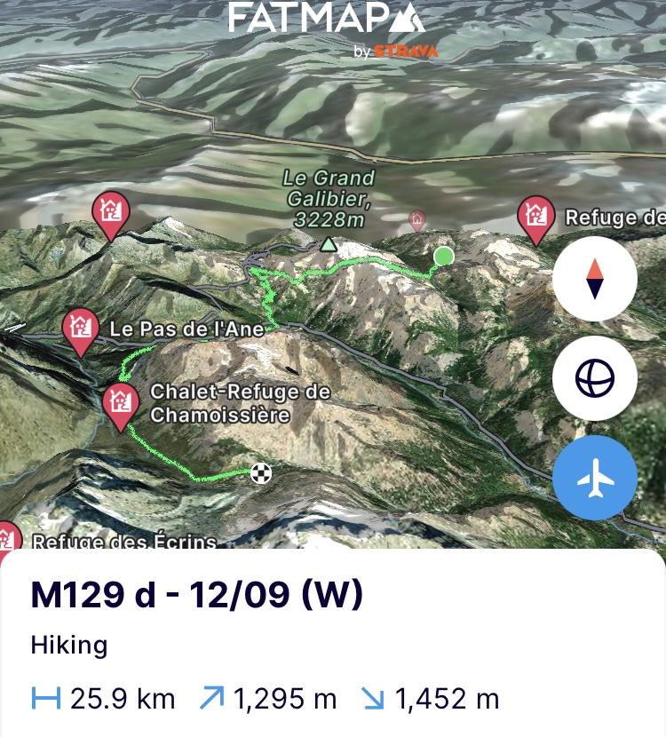
(Donderdag 12/09) Geen Italianen deze keer maar wel sneeuw. Door de koude is de regen overgegaan in sneeuw. Op het tentzeil ligt een mooi pak. Het katapulteert me terug naar de eerste maanden van deze tocht toen het nog sneeuw vreten was. Niet zeuren, alle laagjes terug aan en het huishouden inpakken. Het groene en rotsachtige van het landschap gisteren heeft plaatsgemaakt voor een wit-grijs tafereel. Prachtig om te zien maar ook wel een risico voor vandaag. Door de koude ‘s nachts is de regen die eerst viel omgevormd tot een dunne ijslaag op de rotsen en paden en daar is dan nog een verhullend laagje sneeuw op gevallen. Ik maak me alvast op voor een Bambi-on-ice tafereel.
Met onmiddellijk een klim aan het begin van de dag is de motor direct warm gestookt onder al die laagjes. Naar boven gaan en de graat volgen tot aan de Col Termier (2898m) is perfect te doen maar wel uitkijken. Afdalen dat zal een ander paar mouwen worden. Gelukkig komt de zon er wat door en dat doet de ijslaag een beetje ontdooien. Goed voor alles wat op het oosten en zuiden gericht is maar achter de col moet ik een steil stuk afdalen in een couloir onder de Grand Galibier (3228m) door. De couloir heeft nog geen zon gezien en het is een pittige technische afdaling die er nog goed verijsd bij ligt. Ik denk dat nu ook mijn tweede been vasthangt aan de keukentafel bij moeder.
Zonder kleerscheuren en met het nodige amusement geraak ik door de couloir. Net eronder stoot ik op een voltallige familie steenbokken. Perfect terrein voor hen. De rugzak gaat even af en ik sluip dichter. Ze laten zich gewillig fotograferen. Een beetje verder nog 3 gemzen. De voordelen van onbetreden paden. Het pad loopt verder tot net onder de Col du Galibier die uiterst populair is bij wielertoeristen en vaak in de grote rondes voorkomt. Aan de overkant van de vallei ligt het Ecrins nationaal park dus afdalen en de vallei oversteken. Het was al lang geleden dat ik een wandelstok om zeep hielp, dus tijd om daar verandering in te brengen. Een iets te gezwinde afdaling door het natte gras en een stok breekt mijn val. Rots met ijs doe ik alsof het niks is maar bij nat gras ligt Van Poeck op zijn gat.
Ook dat nog. Geen 2 stokken betekent geen tent opzetten. Ik loop dus door naar de Col du Lautaret waar ik zeker mobiel netwerk moet hebben en bel even met het thuisfront. Ze zullen een vervanger opsturen naar de volgende rustplaats. Wat zou ik toch zijn zonder hen. Vanavond sneeuwt het echter opnieuw en omdat na wat rond bellen de hutten vol blijken te zitten, ben ik opnieuw veroordeeld tot de tent. Op zoek dus naar een houten stok ad interim. Niet evident als je doorgaans boven de boomgrens loopt. Even verderop, wanneer ik het nationaal park binnen loop, hebben de opzichters pas gesnoeid. Zoekend naar iets niet te dik maar ook niet te dun heb ik er snel eentje beet. Perfecte dikte en nog goed flexibel om windstoten op te vangen.
Ik trek verder tegen de bergflank het nationaal park in door een schitterende vallei met steile en imposante bergwanden. De wind zit hard en ijzig in de rug. Ik loop dus tot voorbij de bergpas aan het einde van de vallei om uit de wind naar een slaapplek te zoeken. Eens ik die gevonden heb, uit de wind tussen een aantal grote rotsblokken, zet ik snel, in de laatste uren zon, de tent op. Ze is nog deels bevroren van de nacht ervoor. De zon schijnt nog volop maar daar is de eerste sneeuw al. Kermis in de hel noemen ze dat. De temperatuur is dan ook plots geweldig gezakt en met de kou op mijn lijf kruip ik onmiddellijk de tent in. Alle lagen uit en direct de slaapzak in. Koken en eten vanuit mijn cocon en hopelijk richting warmere oorden in dromenland.
https://fatmap.com/adventureid/158202922/m129-d-12-09-w
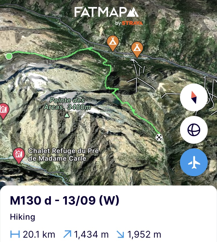
(Vrijdag 13/09) Opnieuw wakker worden in een laagje sneeuw. Niet zo intens als gisteren maar de ijzige wind snijdt hard tegen de tent aan. Dus stapjes bedenken van wat eerst en wat daarna in deze condities. Ijzig koud, dus ontbijt zal voor onderweg worden tijdens het warm lopen. Het huishouden deels inpakken en dan de tent uit om die dan als eerste in de zak te moffelen. Snel al de rest erbij en op weg. Vinger- en teentoppen zijn verkleumd, dus snel de afdaling in. Prachtig zicht op de vallei aan het Lac de la douche maar de vingertoppen zijn nog te verstijfd in de handschoenen om nu foto’s te nemen. Een warme douche zou hen deugd doen.
Ik daal volledig af tot in Le Casset om er in de lokale bar even op te warmen en met een gebrekkig 3G signaal af te stemmen met Martin over hoe we in de komende dagen Les Barres des Ecrins zullen aanpakken gezien de condities. Wat mails sturen en twee warme koffies later trek ik in de nog steeds ijzige wind maar toch al bij 0 graden terug omhoog richting Lac de l’Eychaude. De enige klim van de dag die me wel warm moet krijgen. De komende dagen wordt het warmer maar hoog daarboven zal het blijven vriezen. Het wordt dus uitkijken hoe de zuidflank er zal doorkomen.
Met al het geregel van de dag beland ik in de klim aan de verkeerde kant van de rivier. De rivier staat goed gezwollen en met deze temperaturen heb ik absoluut geen zin in een nat pak. Heen en weer laveren op zoek naar een goede oversteekplaats, dan een kattensprong en ik ben aan de overkant. Verder in de klim naar de Col des Grangettes (2685m). In één keer gaan de 750 hoogtemeters eraan. In de col raast de wind als een bezetene en is het vasthouden aan de rots om niet uit de passage geblazen te worden. Ook in de rest van de afdaling langs de bergflank blijft de wind verraderlijk en komt ie soms van over de bergpas vallen en slaat je uit je evenwicht. De derde poot van de keukentafel bij mijn moeder. Beneden aangekomen in de vallei en net buiten het nationaal park is het genoeg geweest. Verder moet ik niet lopen. Morgen bekijken we of een beklimming van de Barres des Ecrins alsnog haalbaar zal zijn. Indien niet dan neem ik een andere richting naar de rustplaats. De tent komt terecht tussen de struiken en met de ijskoude wind die blijft razen kruip ik snel van kop tot teen in de dons om zo te koken en hopelijk een laatste vriesnacht te doorstaan.
https://fatmap.com/adventureid/158203010/m130-d-13-09-w
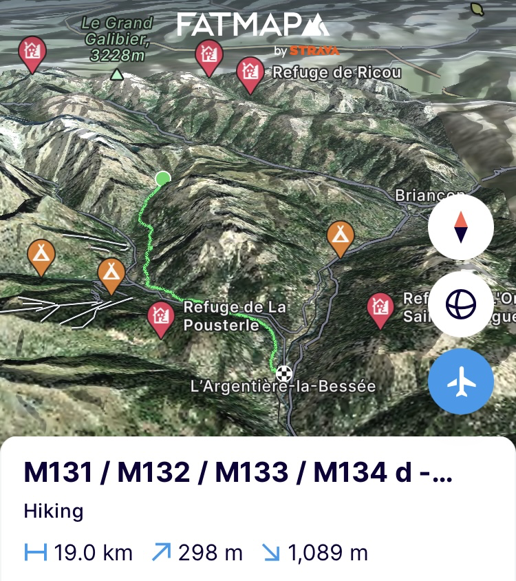
(Zaterdag 14/09) Alvast geen verse sneeuw meer, de tent heeft de aanhoudende windstoten doorstaan. Inpakken en met de wind in de rug loop ik de vallei uit. Aan het einde van de vallei op het kruispunt met links richting rustplaats en rechts richting Barres des Ecrins, bel ik met Martin om samen de condities te bekijken. Helaas is er aanzienlijk wat sneeuw gevallen op hoogte en blijft het er ijzig koud door de wind. Ook in andere gebieden zoals Chamonix en de Aosta vallei is er enorm wat sneeuw gevallen en heersen er boven 4000m zelfs nieuwe recordtemperaturen tot voorbij de -20 graden Celsius.
Niet top dus om door de rotswand te kruipen. Ook andere gletsjerroutes zijn te risicovol geworden doordat de nieuwe sneeuw, in combinatie met de harde wind, dunne sneeuwbruggen over de bestaande gletsjerspleten legt. Aan het einde van de zomer zie je doorgaans alle gletsjerspleten zitten maar dit weer maakt dat je plots nog zeer weinig ziet en het een groot mijnenveld wordt. Spijtige zaak, ik had graag eens met Martin geklommen maar zo zijn de bergen nu eenmaal. We vinden elkaar wel eens op een ander moment. Hij wenst me nog geweldig veel succes. We haken in en ik zet mijn tocht naar links verder richting rustplaats in Argentière-la-Bessee.
Een rustige wandeling langs de bergflank die me tot in Les Vigneuax brengt. In de lokale bakkerij stop ik even voor dik belegde sandwiches en koffie. Nog eens goed eten. Het lichaam had het nodig. Nog een kleine 5 km tot aan de rustplaats en die gaan er in geen tijd aan. Met de toppen in de rug en een niet al te hellend pad is de frustratie er snel afgetrapt. En nu wassen en schrobben… en…
https://fatmap.com/adventureid/158203049/m131-m132-m133-m134-d-14-09-w
Op naar Monaco!
Bergse groeten en tot snel!
————— ENGLISH VERSION —————
(Tuesday 10/09) I can no longer call them rest days. There is always something to do. Buying food for the next stage, looking for gas cartridges, rebooking rest stops, washing, shaving, answering emails, calling home, an interview for a magazine, etc. A day of rest is therefore quickly over. Perhaps I should call them binge-eating days. You can't imagine what I eat on such a day. 3 bags of chips, chocolate, 2 bags of sweets, half a kilo of grapes, 4 bananas, half a kilo of blueberries, 4 liters of soda, ... and then I haven't even counted the morning and evening meal. The body has enjoyed it and feels completely great again. Nevertheless, I start the stage at an easy pace. I forgot to charge the watch so I do that first while I read the news. At 9 am I go back to the village square where I stopped on the previous stage and sit down on the terrace for coffee. Coffee finished and I start. Part 17 of the tour.
I don't walk far because there's a bakery a kilometre further on, so I stop for more coffee and croissants. As I said, at an easy pace. Around 11am the sun comes out and the stage really starts. I don't go far today. Only 15km and 1500 metres of elevation gain. The patella tendon in my left knee was a nuisance yesterday and on the last day of the previous stage. So I take it easy for a while so that I will definitely reach Monaco. I leave the sad Modane behind me and head up a valley that ends at a right angle to it. On to the Les Écrins national park.
Today's route runs the full 15km in an ascending line along the GR5. My legs are boisterous and the first 500 metres of elevation are completed at a high pace. I sit in the sun for almost an hour to keep them calm. But when I start again, the remaining 1000 metres of elevation gain are completed at an equally fast pace. The path that the via alpina has now also joined is not the most beautiful either and lends itself to miles of stamping. Only when it merges into the GR57 that runs around Mont Thabor (3178m) here, I reach the Col de la Vallée-Étroite (2438m) and the beautiful Vallon du Peyron valley and the rock face that envelops it. A bit further and the day is over. In a circle of stones next to the path where tents have stood before, I put mine up. It is 3 o'clock. Enjoy the sun a bit more, eat, write and go to bed on time. Tomorrow a bit more but not too much with the tendon in mind. When I am almost dozing off and it is almost pitch dark outside, I am woken up by 3 Italians in trainers. They have to go to the hut that is 3km back but have no idea how. On Google maps on his phone one shows me where they had ended up and asks me to indicate exactly where the hut is. A tip: Google maps is useless in the mountains. There are no paths and huts are not always there either. Fortunately, the hut is next to a lake and I can find that on his phone. But the group is panicking because they also do not have headlamps to follow the path. After much ado, I crawl out of my sleeping bag and tell them that I will drop them off halfway along the path. A general sigh of Italian relief. Italians and topography are still a bit of a tangle. Clothes on, headlamp on and they the light on their phones and we head out into the dark. On the way I show them how to recognize the path and where they can find markings. Once the most obscure passage in the path is behind us, I say goodbye and give them a ‘high level’ idea of how the rest of the path runs. A few ‘mille grazies’ later I am on my way back to my duvet. And now to sleep. (https://fatmap.com/adventureid/158202757/m127-10-09-w)
(Wednesday 11/09) It has frozen and you could feel it. The nose that sometimes peeped out of the sleeping bag at night and met the ice cold air woke me up a few times. So no oatmeal this morning because it would have frozen by now. So I'll eat the excess bars and start the climb. I hope that the Italian company from yesterday has found the hut because a night in this cold outside is no joke. A quiet day today with mainly a climb at the start of the route to just below Mont Thabor (3178m) via the GR57. The valley below is still covered in a thick carpet of clouds but up here the sun is already coming through.
Once below the summit, the path bends down a slope in different rock layers and colours towards the national park. In the distance, the 2 4000m+ peaks of the park already stand out against the horizon. The Barres des Ecrins (4102m) and Dôme de neige des Ecrins (4015m). I had to adjust the initial route a bit because the other peaks to cross were in too bad a condition in terms of routes. Crossing the park is not easy because the mountain flanks are very steep and you quickly end up in alpine terrain and routes. So we will try to climb them from the south side in a few days. But first continue here towards Roche du Chardonnet (2950m) via the ridge that runs there. In my immense preference for doing ridges, I climb the ridge too early where the path first follows the flank. After startling 2 ibexes, there is no other option than to climb down a part of the steep mountainside. If my mother had seen it, she would have tied me to the kitchen table leg.
Safe and sound back on the path, it is through the rock debris to end up a bit further on the ridge and follow it towards the top. A great view from here of the national park and its snow-capped peaks. Out of the wind on the top it is resting with the 4G signal that I found. Quickly look at and follow up on some things and then down past the many hikers who follow the GR57 here. At the bottom of the Refuge de Drayères it is time to stop for sugars and charge the phone. The weather will change around 4 pm and give rain for the rest of the day. So the rain cover goes over the backpack and I continue on the remaining 9km for today.
In the Col des Cerces (2574m) it is manoeuvring and waiting between 2000 sheep that cross the pass. When the last one has passed, I thunder down. At the lake of the same name the rain starts to come up. I don't feel like a wet household since it is also icy cold and so I quickly put up the tent and cook dinner. I will take the remaining kilometres tomorrow. Now stay dry and warm and hope that we don't have any Italians at the door later. (https://fatmap.com/adventureid/158202834/m128-11-09-w)
(Thursday 12/09) No Italians this time but snow. The rain has turned into snow due to the cold and there is a nice layer on the tent canvas. It catapults my thoughts back to the first months of this trip when it was still eating snow. No whining, put all the layers back on and start packing up the housework. The green and rocky landscape of yesterday has made way for a white-grey scene. Beautiful to see but also a risk for today. Due to the cold at night, the rain that fell first has turned into a thin layer of ice on the rocks and paths where a concealing layer of snow has fallen. I am already preparing myself for a Bambi-on-ice scene.
With an immediate climb at the beginning of the day, it is ideal to warm up the engine immediately under all those layers. Going up and following the ridge to the Col Termier (2898m) is perfectly doable but I have to watch out. Descending will be a different matter. Fortunately, the sun comes through a bit and thaws the layer of ice a bit. Good for everything facing east and south, but behind the pass I have to descend a steep section in a couloir under the Grand Galibier (3228m). The couloir has not yet seen the sun and it is a tough technical descent that is still quite icy. I think my second leg is stuck by now to my mother's kitchen table.
I get through the couloir without any tears in my clothes and with the necessary amusement. Just below it I come across a whole family of ibexes. Perfect terrain for them. I take off my backpack and creep closer but they willingly let me photograph them. A little further on I see 3 more chamois. The advantages of untrodden paths. The path continues to just below the Col du Galibier which is extremely popular with cycling tourists and often features in the big tours. On the other side of the valley lies the Ecrins national park so I descend and cross the valley. It has been a long time since I ruined a walking stick so it was time to change that. A slightly too fast descent through the wet grass and a stick breaks my fall. He does rock with ice as if it is nothing but Van Poeck falls flat on his ass when it comes to wet grass.
Now this aswell. No 2 poles means no tent to pitch. So I walk on to the Col du Lautaret where I should definitely have mobile network and call home. They will send a replacement to the next rest stop. What would I be without them. Tonight it is snowing again and since the huts are full after some calling around, I am condemned to the tent again. So I look for a wooden pole ad interim. Not easy if you usually walk above the tree line. A little further on when I enter the national park, the supervisors have recently pruned. Looking for something not too thick but also not too thin, I quickly find one. Perfect thickness and still flexible enough to absorb gusts of wind.
I continue along the mountainside into the national park through a beautiful valley with steep and imposing mountain walls. The wind is strong and icy at my back. So I walk past the mountain pass at the end of the valley to look for a place to sleep out of the wind. Once found out of the wind between a number of large boulders, I quickly put up the tent in the last hours of sun, which is still partly frozen from the night before. The sun is still shining brightly, but the first snow has already arrived. They call it a fair in hell. The temperature has suddenly dropped tremendously and with the cold on my body I immediately crawl into the tent. All layers off and straight into the sleeping bag. Cooking and eating from my cocoon and hopefully towards warmer places in dreamland. (https://fatmap.com/adventureid/158202922/m129-d-12-09-w)
(Friday 13/09) Waking up again in a layer of snow. Not as intense as yesterday but the icy wind is cutting hard against the tent. Waking up and thinking of steps of what first and what next in these conditions. Icy cold so breakfast will be for on the road while warming up. Partly packing the household and then out of the tent to put that last one in the bag first. Quickly all the rest with it and on our way. Fingertips and toes are frozen so quickly into the descent. Beautiful view of the valley at the Lac de la douche but the fingertips are still too stiff in the gloves to take pictures of it. They could really use a warm shower now.
I descend all the way down to Le Casset to catch up in the local bar and, with a poor 3G signal, coordinate with Martin on how we will tackle Les Barres des Ecrins in the coming days given the conditions. A few emails and two hot coffees later I head back up towards Lac de l’Eychaude in the still icy wind but already at 0 degrees. The only climb of the day that should warm me up. The coming days it will get warmer but high up it will continue to freeze. So it remains to be seen how the southern flank will come through.
With all the arranging of the day I end up climbing on the wrong side of the river. The river is quite swollen and I don’t feel like getting wet in these temperatures to get across. Tackling back and forth in search of a good crossing point and then it comes down to a cat's leap and I'm on the other side. Further on in the climb to the Col des Grangettes (2685m). In one go the 750 meters of elevation gain are taken. In the pass the wind rages like a madman and it is a matter of holding on to the rock to not be blown out of the pass. Also in the rest of the descent along the mountainside the wind remains treacherous and sometimes it comes from over the mountain pass and knocks you off balance. Arrived at the bottom in the valley and just outside the national park it is enough. I don't have to walk any further because tomorrow we will see if a climb of the Barres des Ecrins is still feasible. If not then I take a different direction towards the resting place. The tent ends up between the bushes and with the icy wind that continues to rage I quickly crawl from head to toe into the down to cook and survive a last freezing night. (https://fatmap.com/adventureid/158203010/m130-d-13-09-w)
(Saturday 14/09) No more fresh snow, but the tent has withstood the persistent gusts of wind. Pack up and walk out of the valley with the wind in my back. At the end of the valley at the crossroads with left towards rest place and right towards Barres des Ecrins, I call Martin to check the conditions together. Unfortunately, a lot of snow has fallen at altitude and it remains icy cold there, helped by the wind. Also in other areas such as Chamonix and the Aosta valley a lot of snow has fallen and above 4000m there are sometimes new record temperatures of over -20 degrees Celsius.
Not great to crawl through the rock face. Other glacier routes have also become too risky because the new snow in combination with the strong wind creates thin snow bridges over the existing glacier crevasses. At the end of the summer you usually see all the cracks but this phenomenon makes you suddenly see very little and it becomes a big minefield. Too bad and I would have liked to climb with Martin but that's just the way the mountains are. We’ll meet up again at another time. He wishes me lots of luck. We disconnect and I start my journey to the left towards the rest stop in Argentière-la-Bessee.
A quiet walk along the mountainside that takes me to Les Vigneuax. In the local bakery I stop for thickly filled sandwiches and coffee. Another good meal. The body needed it. Another 5 km to the rest stop and they'll be gone in no time. With the peaks at my back and a path that is not too steep, the frustration is quickly kicked off. And now wash and scrub… and… (https://fatmap.com/adventureid/158203049/m131-m132-m133-m134-d-14-09-w)
Off to Monaco!Mountain greetings and see you soon!
Start hier met schrijven...
