meer foto's op fatmap, zie link in tekst
————— NL version (ENG version below) —————
(Vrijdag 30/08) Half dagje rust heeft goed gedaan aan de benen. Eens douchen en de kleren wassen heeft dan weer goed gedaan voor de medemens. Vandaag begint de inhaalrace naar de geplande route na de omweg die ik deed om de Mont Blanc mee te pikken op mijn pad. Ondanks die omweg blijft de filosofie van de tocht dezelfde. Dus klim ik direct steil omhoog de bergflank op, richting Mont Jolly (2524m). Het is geen technisch pad maar wel lekker pittig qua profiel. Een gems raast op nog geen 5 meter van mij de flank af. Dus ook een tamelijk ongebruikt pad.
Na de eerste 900 hoogtemeters kom ik op de bergkam aan en is het even rusten om te drinken. Vanaf hier is het de bergkam volgen tot aan de top en vandaar voor de volgende kilometers van de ene top naar de andere via Tête de la Combaz en Tête du Véleray (2445m) tot aan Aiguille Croche (2487m). Een geweldige trailrun route alvast met weinig hoogteprofiel maar een magistraal zicht. Een paar goudarenden cirkelen boven de laatste top op zoek naar eten. Ze blijven cirkelen tot nog geen 15 meter boven me maar als ik op de top ben zijn ze spoorloos verdwenen. Ik leg me een half uur in het gras met zicht op de Mont Blanc. Het weer is perfect. Er zal dus wel een hoop volk richting top aan het trekken zijn en Kilian zal van top naar top aan het hoppen zijn. Als je ooit in de buurt bent en je wil niet met alle duizenden andere hikers op de Tour du Mont Blanc belanden, , dan is deze route zeker een aanrader. Bovendien heb je vanop de bergkam een prachtig zicht op het westelijke deel van het Mont Blanc massief en al zijn toppen.
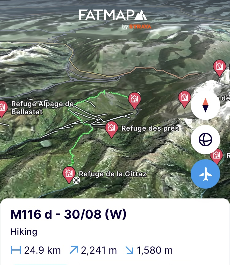
Aan de Aiguille Croche daal ik af naar de Col du Joly (1989m) en na wat suikers bij Chez Gaston draai ik mijn rug naar het Mont Blanc massief en trek richting Col de la Gittaz. Daar zullen er bijna 25km en 2500 hoogtemeters in de benen zitten, dus moet ik ergens op zoek naar een slaapplaats. De vallei achter de pas blijkt echter kurkdroog. Dus nog een lange afdaling om water te zoeken maar niet te ver want om de hoek ligt een hut en daar houden ze niet zo van kampeerders. Net voor ik de vallei zou induiken richting hut vind ik een riviertje. Het komt uit de bergen en dus ver weg van de koeienweides. Zwemmen, koken, eten en slapen.
https://fatmap.com/adventureid/155112843/m116-d-30-08-w
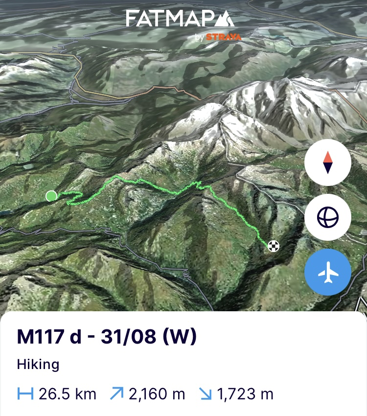
(Zaterdag 31/08) Geslapen als een roos. Het zal vitaal zijn om in deze etappe terug op de planning te geraken en 2 dagen achterstand in te halen. Het feit dat de zon tegen het einde van het seizoen later opkomt, helpt niet echt. Als om 6u de wekker gaat, is het met de hoofdlamp aan alles snel inpakken want vandaag staan er pittig wat kilometers op het programma. Bij de opkomende zon duik ik direct via een canyon de volgende vallei in. Een pracht van een pad dat uitgehouwen is in de steile rotswanden van de canyon.
In de vallei achter de canyon is het klimmen tot aan de smakelijke Col de la Sauce (2307m). Het doet me heel de klim denken aan cocktailsaus. Afgrijselijk lang geleden dat ik dat nog op mijn bord heb gehad. In de col kom ik terecht op de Tour du Beaufortain en de GR5, die hier langs de west Alpen schampt op weg naar Nice. Ik zal hem nog een paar keer tegenkomen de volgende weken. Ook deze beide routes zijn geweldige alternatieven als je niet terecht wil komen op de overbevolkte Tour du Mont Blanc en toch een geweldig zicht op de Mont Blanc wilt hebben. Rustiger en mooier dus. Een mooi voorbeeld is de arrête des gîtes die ik vanaf hier volg en die opnieuw pal op de bergkam loopt. Uiteindelijk brengt ie me terug bij de Tour du Mont Blanc. Die moet ik volgen tot aan refuge Les Mottets alvorens afscheid te nemen van het massief. Een geweldig authentieke hut waar ik een middagpauze inlas want het wordt serieus heet om te stappen.
Als er wat wolken komen opzetten en de temperatuur een stuk daalt, start ik de klim naar de Col de l’Ouillon (2612m). Het contrast met de Tour du Mont Blanc kan niet groter zijn. Het is een geweldig wild pad waar je geen twee voeten naast elkaar kan zetten. Het lijkt op een beestenpad. Ik kom onderweg slechts één markering tegen en af en toe wat steenmannetjes, die gemaakt zijn door zij die er zich ook aan waagden. Love it! De klim gaat er in een keer aan. De benen voelen zich top. Als ik in de bergpas zit, vind ik één blokje 5G ontvangst en dus tijd om te bellen met het thuisfront en een update de wereld in te sturen want de voorbije etappe ligt ondertussen al 2 dagen achter me zonder nieuws.
Achter de col strekt zich een geweldig groene vallei uit waar een kudde schapen, herder en honden door glijden. Ook hier ligt er nog steeds geen duidelijk pad en is het dus op een paar steenmannetjes, twee rode verfstreken ergens op een steen en vooral de gps lopen. Als ik verderop de kudde schapen terug tegenkom in het midden van wat het pad moet zijn, krijg ik hun vertrouwde beschermers op mijn hielen. Drie Pyreneese berghonden stormen op me af. Grote wit grijze beesten zijn het. Dit is niet de eerste keer dat dit me overkomt. Toen ik de Pyreneeën overstak van de Atlantische Oceaan naar de Middellandse Zee, werd ik al eens uit het niets aangevallen door eentje. Met de wandelstokken kon ik hem toen van me afhouden. Deze keer zet ik me er even bij neer en laat ze vooral blaffen en wennen aan mij. De vallei wordt immers smaller en ik kan niet direct een kant op. Uiteindelijk begin ik te klimmen tegen de bergflank op om verderop in een grote boog om de kudde te geraken. Ze houden me blaffend en nauwgezet in de gaten.
Ik geraak er voorbij maar voor de kuiten was dat sinds die laatste klim geen cadeau. Ik ga dus op zoek naar een slaapplek waar het vee niet huist. Niet evident want schapen worden koeien en voor ik het weet sta ik al 4 kilometer verder in de vallei. Ik trek nog een stukje door voorbij de weides. Als ik denk een verlaten stuk van de vallei gevonden te hebben, stoot ik achter een struik terug op een Pyreneese berghond. Het beest is oud maar blaft nog als de beste. De volgende vallei en bergpas inklimmen is een maatje te veel voor me. Ik klim hoger de vallei in weg van de hond op zoek naar een slaapplek. Aangezien ook hier een kudde schapen met herder rondtrekt, is het een beetje onduidelijk hoe die laatste tegenover wildkamperen staat. Ik zet me neer en wacht af of hij reageert. De herder heeft geen oog voor me. De troep Pyreneese berghonden die bij de kudde horen, hebben me wel opgemerkt en komen voltallig en luid blaffend dag zeggen. De herder reageert er niet op en als iedereen terug in zijn normale doen is, zet ik me nog verderop uit het zicht en begin aan het avondritueel nog net voordat de bliksem komt opzetten.
https://fatmap.com/adventureid/155100898/m117-d-31-08-w
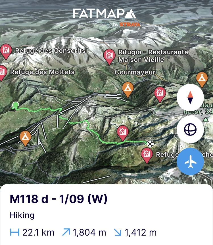
(Zondag 1/09) Vandaag vallei hoppen. Doel is om 4 valleien verder te geraken maar eerst uit deze geraken. De herder mocht gisteren dan wel geen oog hebben voor mij en mijn tent, hij heeft wel zijn kudde schapen op het midden van het pad te slapen gelegd. De aanloop naar de eerste bergpas, Col de Forclaz (2525m) is dus opnieuw duelleren met de berghonden die de kudde bewaken. Opnieuw moet ik het onderspit delven en duwen ze me richting een steile bergflank voor nog maar eens een kuitenbijter tot ik terug op het pad geraak. Maar ook dat is beter dan een berghond die in je kuiten bijt.
Een beetje later sta ik in de bergpas. Op naar de volgende die zeker niet de mooiste is aangezien ie in een skigebied ligt maar wel iets meer historische waarde heeft met de Col de la Traversette (2383m). Volgens recente historische opgravingen zou het wel eens goed kunnen dat Hannibal langs hier overstak met zijn olifanten richting Rome. De discussie blijft gaande over welke weg het nu exact was. Eens voorbij de skiliften en pistes die de vallei verminken, is het verderop niks dan pracht. Geen hond te bespeuren op de paden, die kronkelen door ruwe en met struiken omgeven landschappen. Prachtig terrein hier in de Haute Savoie.
Voorbij de derde bergpas, de Passage de Louïe Blanche (2524m), kan ik de bosbessen (myrtilles) niet meer negeren en is het pauzeren en eten tot mijn vingertoppen paars zien. Even verderop val ik nog binnen in de Refuge de Ruitor voor suikers maar als de wolken dreigender komen opzetten, ga ik snel terug op weg naar de laatste bergpas, Col de la Sassière (2520m). Nog even alles uit de kast halen en de laatste 500 hoogtemeters er aan een hoog tempo doorjagen om snel bij het Lac Noir te geraken net achter de bergpas en mijn tent op te zetten voor de regen losbarst. Om de motivatie te bevorderen gaat de gletsjerbril op want door die lenzen ziet elke wolk er drie keer zo dreigend uit. Een uurtje later staat de tent op aan het meer maar het aangekondigde onweer laat op zich wachten. Ik kruip vroeg het bed in om morgen snel in Valgrisenche in Italië te zijn om er mijn vooruitgestuurde rantsoenen op te halen.
https://fatmap.com/adventureid/156961903/m118-d-1-09-w
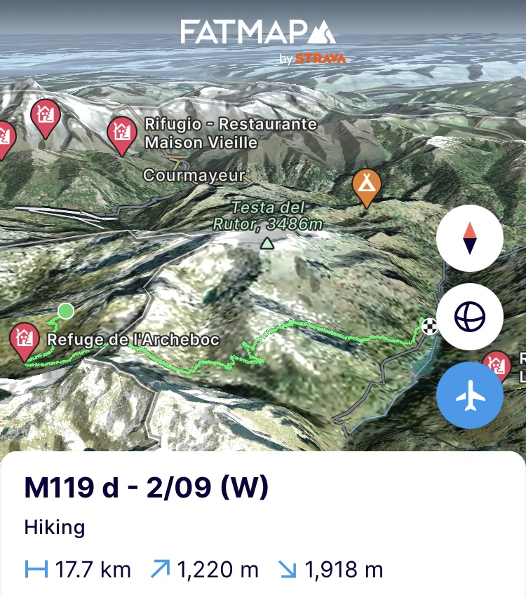
(Maandag 2/09) Vroeg uit de veren en afdalen naar Refuge l’Archeboc voor koffie. Het weer is minder, het is serieus bewolkt. De huttenwirt geeft me mee dat het aan de Italiaanse zijde nog erger is en daar moet ik net heen. “Als de wind aan deze kant staat, dan is het garanti prijs in Italië”. De lokale meteorologische wijsheid krijg ik er gratis en voor niks bij. Het is wat het is. Ik neem afscheid en begin aan de klim naar Col du Mont (2632m). Onderweg kom ik de stappers tegen die al eerder vanuit de hut vertrokken waren. Als ik in de bergpas sta, hangt die vol met wolken. De stappers van eerder zie ik niet meer komen. Ze zullen rechtsomkeer gemaakt hebben.
Aangezien het goed koud is in de bergpas trek ik snel door naar de volgende. Een stuk afdalen tot aan een alm en terug naar boven. Het is duidelijk dat ik terug in Italië ben. De gps zegt A, de kaart B en de realiteit C. Het is zoeken naar een speld in een hooiberg om het juiste pad te vinden. Nochtans zou ik hier een stuk van de Via Alpina doen maar die is moeilijk terug te vinden. Veel heen en weer zwerven later geraak ik over de bergpas. Het weer is zeker niet zo slecht als de wijsheid van de huttenwirt voorspelde. Nu enkel nog afdalen tot in Valgrisenche. De benen gaan in trailrun modus en zijn moeilijk te stoppen. Ik zal blij zijn als mijn trailrun schoenen aangekomen zijn, want naar beneden denderen op C schoenen mist toch serieus wat demping.
Een dorp boven Valgrisenche kom ik op de middag aan in het hostel waar ik alles naar toe gestuurd heb. Even pasta eten, de rugzak achterlaten en in Valgrisenche een kilometer verderop op zoek naar havermout en rozijnen. Het dorp kent maar 80 inwoners en de kruidenier is dicht. Een bord aan de deur zegt dat je moet aanbellen, als je voor een gesloten deur staat. De bel geeft niks. Na een paar keer bellen, komt uit een huisje verderop een oude vrouw die eerst in het Italiaans en dan in gebrekkig Frans aangeeft dat haar zoon er niet is. Om 3u zal hij terug zijn. Ik vat post op de bankjes op het dorpsplein tegenover de zaak. 3u wordt 4u. Uiteindelijk komt ze naar buiten om zich naast me neer te zetten en me het goede nieuws te melden dat het hoogstwaarschijnlijk nog later zal zijn. Ze tettert een half uur volledig vol met weetjes over de regio, het weer en tot driemaal toe de reden waarom haar zoon er niet is. Die laatste is naar beneden afgezakt om een TL lamp te gaan halen. Uiteindelijk wordt 4u 5u en als ze het op haar heupen krijgt dat haar zoon er nog steeds niet is, haalt ze zijn nicht erbij die ook een sleutel van de winkel heeft.
Op het moment dat ze de winkel open doet, komt de zoon eraan. Hij is het stereotype van een verstrooide professor. Zijn winkel ook. Niks geordend en het kassasysteem zijn eindeloos veel papiertjes met gekribbel op. Het handvol mensen dat al stond te wachten aan de winkel, negeert ie. Eerst de TL lamp vervangen. Ondertussen is naast de nicht nog een familielid mee achter de toonbank gekropen. Ik probeer hen uit te leggen dat ik op zoek ben naar havermout en rozijnen. Veel heen en weer getier tussen toonbank en winkelier die in de TL behuizing hangt in de befaamde Italiaanse stijl. Het helpt ons niks vooruit en na een tijd geef ik het op. Ik zeg hen dat ik ‘s ochtends wel macaroni zal eten want ik heb toch een paar rantsoenen teveel besef ik ineens. Een donderslag bij heldere hemel. Ik vrees dat ik gevloekt heb in de kerk want het gezelschap schiet in algehele verontwaardiging nog een versnelling hoger in het getier. Macaroni als ontbijt is hier blijkbaar not done. Ze zijn allemaal een kop tot anderhalve kop kleiner dan ik. Ik voel me omgeven door een horde duiven op een plein. Uiteindelijk maak ik me uit de voeten door te zeggen dat ik nog terug omhoog moet naar het vorige dorp en ze laten me gaan na nog eens de dozen cornflakes, muesli en het gebak voor mijn neus te hebben gehouden. Ik bedank vriendelijk en keer terug.
https://fatmap.com/adventureid/156961970/m119-d-2-09-w
(Dinsdag 3/09) Het ontbijt in het hostel is pas om 7u30. Ik zou dus kunnen uitslapen, maar de klok in mijn hoofd denkt er anders over. Om 6u ben ik klaar wakker. Ik heb dus nog een eeuwigheid om de zak te maken. Ontbijten en terug de vallei in omhoog richting Franse grens. De Italiaanse paden laten me opnieuw in de steek. Hier en daar is het klauteren door de struiken omdat er een stuk van het pad ontbreekt. Gelukkig is de aanloop naar de rifugio Mario Bezzi die een heel eind dieper in de vallei ligt, een stuk duidelijker.
Ik stop er even om wat suikers binnen te steken maar niet te lang want het weerbericht geeft regen vanaf 4u. Ik zet snel door op de laatste klim van de dag naar de Col Bassac Dere (3083m). Een pittige maar prachtige klim die me langs de Gliairetta gletsjer neemt door een maanlandschap van rotspuin. Een gletsjer net zoals de vele andere kleinere broertjes die in de komende 5 tot 10 jaar op het punt staan om te verdwijnen door de klimaatverandering.
Eens in de col zit de etappe voor vandaag erop. Ik loop nog een stuk door tot aan Lago di Goletta. Een beetje lager in de volgende vallei. Het meer is een gletsjermeer waar je in één beeld de imposante top van de Pointe de la Golette, een hangende gletsjer, gepolijste rots, een meer en een meander waarop de heide in bloei staat, meekrijgt. Een meer feeërieke slaapplaats kan ik me niet bedenken.
https://fatmap.com/adventureid/156962042/m120-d-1-3-09-w

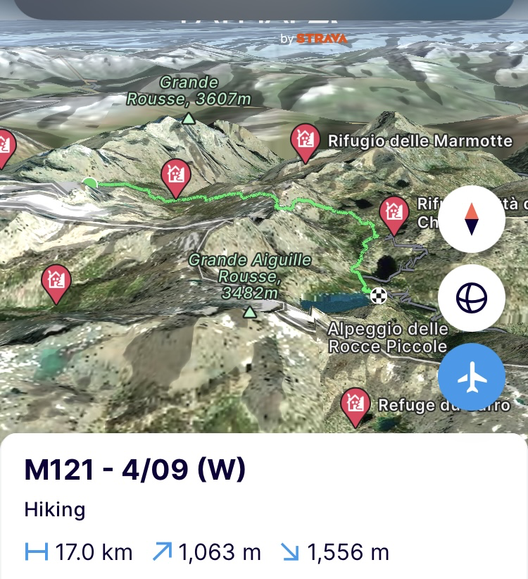
(Woensdag 4/09) Het weer gaat omslaan vanaf vandaag en dat is slecht nieuws voor de afstand die ik nog moet inhalen. Niet getreuzeld dus. Voor de zon op is, ben ik al aan het inpakken. Het zicht dat gisteren nog een mooi kleurenspel was, is deze ochtend volledig omgeven door de wolken. Ik begin dus snel aan nog een stukje afdaling richting volgende vallei om de bergpas, Colle Basei (3160m), zeker tegen de middag over te zijn. Wat daarna gebeurt dat zullen we dan wel oplossen.
Beneden in de vallei stop ik nog even in rifugio Benevolo voor koffie en om de telefoon op te laden. Dat laatste was ik hals over kop vergeten vorige nacht. Als de koffie binnen is, begin ik aan de 1000 hoogtemeters richting bergkam. Ze gaan er lustig in één ruk door. Het wolkenpak trekt dicht, het is dus doortrappen door het maanlandschap tot aan de bergkam. Bovenop de relatief spitse bergkam trek ik nog een stuk door in de route naar de top tot ik aan de linkerkant een pad naar beneden tegenkom. Met tegenzin geef ik het gehuppel van rots naar rots op de bergkam op en begin aan de afdaling. Ondertussen is het beginnen miezeren en de rotsen krijgen een natte film. Geweldig opletten dus in het snelle afdalen. Miezeren gaat over in dikke regendruppels en ondertussen zie ik nog slechts een 10 meter voor me uit. De route vinden die over populaire en minder populaire paden loopt wordt geen evidentie. De Italiaanse topografie helpt ook hier niet.
Als ik aan het stuwmeer, Lago Di Serru, aankom, ben ik doorweekt en verkleumd. Het idee om nog door te steken naar Frankrijk krijgt de spreekwoordelijke handdoek in de ring gepresenteerd. Hoewel de radar een uur opklaringen aangeeft, heb ik zeker 2u nodig voor de klim naar de bergpas, Col du Carro (3150m). Er zitten in de klim ook 2 via ferratas, een stuk gletsjeroversteek en dan nog alles wat er achter de pas ligt. Geen goede cocktail dus met deze condities. Morgen wordt nog slechter met zware onweersbuien en wind. Dus hier stopt het voor vandaag. Ik daal af op zoek naar een schuilplaats om morgen uit te zitten.
https://fatmap.com/adventureid/156962143/m121-4-09-w
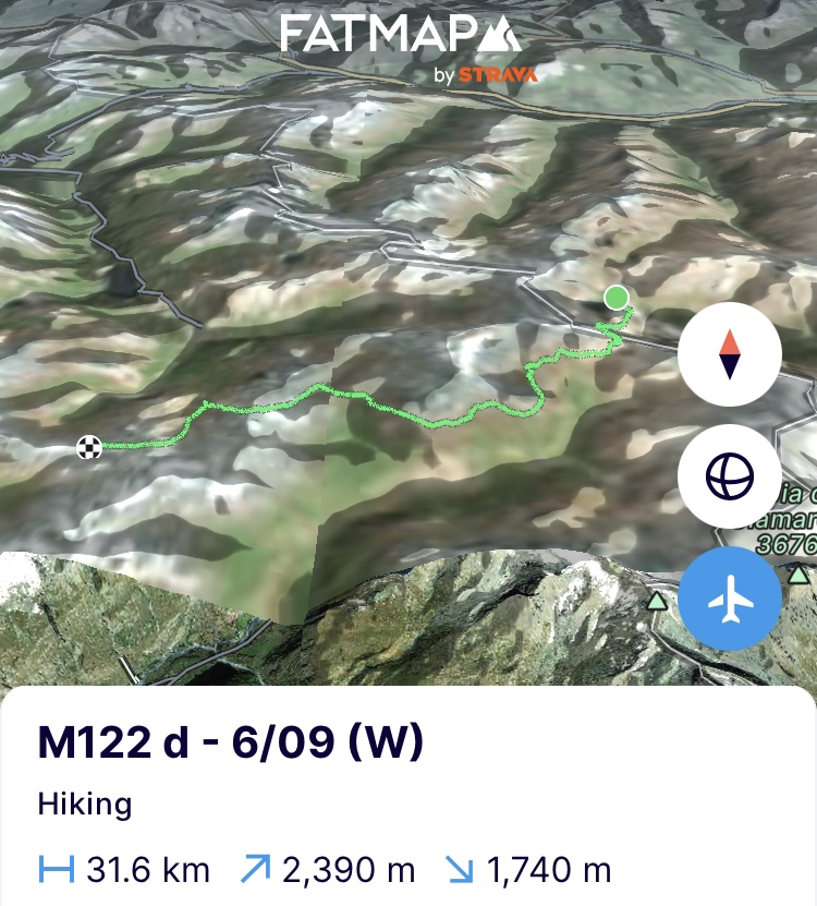
(Vrijdag 6/09) Zware depressies vanuit het zuiden hebben gisteren de hele dag en nacht aan één stuk door regen-, bliksem- en donder-salvo's gelost op de Aosta regio. Het was dan ook heel de dag horizontaal in bed de planning herbekijken in functie van de weersverwachtingen en zaken herboeken. Nog een maand te gaan en ik ben in Monaco. Hopelijk wil het weer wat mee want aan dit ritme zal het meer dan een maand worden voor ik, na mijn Mont Blanc offensief, terug op planning ben. Geen tijd te verliezen dus en terug in de inhaalrace.
Een delegatie van de Italiaanse alpenvereniging die komt wandelen in de regio, zet me maar al te graag terug af waar ik gestopt was. De leider van het gezelschap vertelt me trots hoe hij begaan is met topografie. Ik knik en luister terwijl ik me bedenk dat hij nog serieus wat werk aan de winkel heeft. Driewerf “mille grazie” later begin ik aan de klim naar de Col du Carro. De benen zijn verzuurd en protesteren op de eerste 1000 hoogtemeters, die direct aan het begin van het traject voor vandaag liggen. Ik geef ze wat respijt om er terug in te komen en doe de klim op mijn gemak. Alvast de juiste beslissing om hier eergisteren niet meer door te kruipen. De eerste kilometers is ploeteren door rotspuin en daarna nog een oud gletsjerbekken oversteken waar het puur op de frictie van de bergschoenzolen gaan is. Wel een geweldig prachtige klim en als summum ook nog eens 10 tot 20cm verse sneeuw die gevallen is boven 3000m. Het maakt het unieke zicht op de Col du Carro nog magischer. Bovenop de bergpas staan immers meer dan honderd steenmannetjes. Vaak geen halve meter uit elkaar. Met de verse maagdelijke sneeuw erop en op de omliggende bergtoppen is het alsof iemand een zak poedersuiker heeft laten vallen.
Even genieten van het zicht en dan terug in de race. Snel afdalen tot aan de gelijknamige hut en dan kilometers maken op de plattere balkons en vlaktes die het Nationaal park la Vanoise te bieden heeft. Het beeld met de vers besneeuwde bergtoppen is postkaart-waardig maar de focus gaat vooral naar de benen om die terug in een efficiënte cadans te krijgen. Het protest is over en eens in de buurt van de Col de l’Iseran (2770m) begin ik aan de laatste 2 bergpassen voor vandaag. Ze zijn minder explosief dan de eerste. De benen zitten terug in hun ritme en trekken lustig mee door. Na de eerste, Col des Fours (2976m), stop ik toch nog even bij de Refuge du fond des fours voor suikers om zeker de tweede nog te baas te kunnen. De berghut is de meest idyllische die ik ooit gezien heb. Niet alleen ligt ze in een wondermooie vallei maar is ze ook nog eens opgebouwd uit allemaal kleine houten chalets in plaats van één groot gebouw. Jammer van het blitzbezoek maar hier keer ik sowieso terug.
Ik klim de vallei verder in naar omhoog en na een rotswand gaat ze over in een gigantisch plateau waar enkele herten water aan het drinken zijn. Helaas scrikt ik ze op met mij looppas en moet ik alleen verder het plateau over. Grote steenmannen tot wel twee meter hoog tonen de weg door deze doodse vallei van steen en mos. De ondergaande zon en de wolken maken er een surreëel beeld van. Nog een laatste klim aan het einde van het plateau en de vallei naar de Col de la Rocheure (2910m) aan het einde van een hoger gelegen plateau. Net erachter zet ik de tent op. Meer dan 30km en 2300 hoogtemeters in de benen, dus genoeg ingehaald voor vandaag. Met een ondergaande zon is koken en eten het enige dat nog telt.
https://fatmap.com/adventureid/156962251/m122-d-6-09-w
(Zaterdag 7/09). Vroeg uit de veren maar toch niet zo gemakkelijk uit de warme slaapzak. Het is nog ijzig koud rond de tent hier op 2900m hoogte. Niet zeuren en aan de slag. Een beetje later begin ik aan de afdaling tot aan de refuge de la femma. Gezien de kwakkelende weersomstandigheden zal ik een traverse van de Vanoise gletsjer uit de route knippen. Op hoogte heeft het voor de eerste keer terug serieus bijgesneeuwd tijdens het onweer. Dat gecombineerd met serieuze rukwinden was de ideale combo om bestaande gletsjerspleten te verstoppen en te voorzien van nieuwe dunne sneeuwbruggen. Verder hangt het wolkendek zeer laag en dat beperkt het zicht. Te risicovol dus om alleen over te steken. Zonder nieuwe sneeuwval had alles aan het einde van het seizoen volledig bloot gelegen en kan je niet veel fout doen maar in deze omstandigheden is het te zot er door te kruipen. Dan maar iets lager langs de bergflank op de GR5 kilometers inhalen.
In de refuge geraak ik aan de praat met de huttenwirt die ook al een gedeeltelijke oversteek van de Alpen deed. Als we het hebben over de condities op de Vanoise gletsjer treedt hij me volledig bij. Het gesprek gaat over in het maken van wintertours en voor ik het weet ben ik de tijd compleet uit het oog verloren. Ik verzeker hem dat ik sowieso in de winter nog eens terugkom en ga er snel van door, terug in de inhaalrace. Ik loop de vallei uit en aan de overkant kruip ik de bergflank terug op via de GR5 om de rest van de dag de hele rit langs de flank op en neer te lopen. Het mooie aan de paden in het nationaal park van La Vanoise is dat je niet veel agressieve hoogtemeters zal tegenkomen maar alles eerder glooiend verloopt.
Eindhalte voor vandaag is een stuk op het balkon van La Turra wat de enige plek is waar ik een tent zal kunnen plaatsen. Terwijl ik een hele dag kletterend water tegenkwam en zelfs moest opletten om niet uit te schuiven op natte stenen, loop ik nu door kurkdroog kalkgesteente. Vier bergrivieren die ik op de kaart kan vinden, staan allemaal droog. Het contrast met de overkant van de vallei die bulkt van de bergrivieren, dik bebost en groen is, kan niet groter zijn.
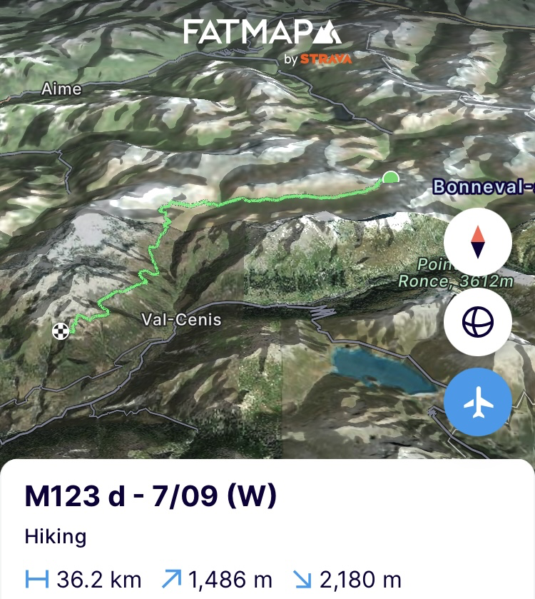
Probleem. Al het water is op. Geen water geen eten. Doorlopen dus. De wind die door de bomen ruist, speelt met mijn voeten en doet me voortdurend denken dat ik water gevonden heb. Meevaller is dat het doorlopen me tot net buiten het park brengt wanneer ik in een kleine canyon een stroompje vind. Er staan immers serieuze boetes op wildkamperen in het nationaal park. De benen hebben het gehad nu er meer dan 35km in zitten. Aangezien de volgende kilometers volledig tegen de bergflank lopen, zal het dus hier een nachtje in de canyon in de bivakzak worden. Het lichaam is op, dus koken en snel de cocon in. Genoeg ingehaald vandaag. Morgen nog 17 km naar de rustplaats en dan anderhalve dag rust voor de beentjes.
https://fatmap.com/adventureid/156962349/m123-d-7-09-w
(Zondag 8/09) De bivakzak onder een sterrenhemel was een mooi uitzicht maar een kwelling voor het lijf. Ik hijs me terug in de nog klamme kleren die ernaar snakken nog eens gewassen te worden op 40 graden. Het lijf kan het ook gebruiken. Het weer verslechtert ook, dus snel terug de route in. In de enige klim van de dag naar de Col du Barbier (2295m) begint het te miezeren. Ik weiger te stoppen om de regenjas aan te doen en de regenhoes over de rugzak te trekken uit schrik dat de motor zou stilvallen. De benen voelen zwaar. Ik zie het dan maar als het voorprogramma. Straks de rest van de was.
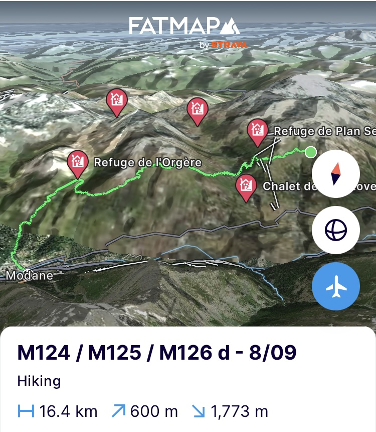
Als de miezer aanzwelt, schuil ik even in refuge de l’orgère en dan is het verder afdalen naar Modane, de eindhalte van deze etappe. Over de stad valt er niet geweldig veel te zeggen. Enkel dat ze er in de regen nog somberder uitziet. Veel leegstand. Weinig te doen. Op de enige camping in de stad neem ik mijn intrek voor het slechte weer van de volgende dag en haal er mijn rantsoenen op die uit België zijn aangekomen. Tijd voor dat kookwasprogramma… en dan…
https://fatmap.com/adventureid/156962396/m124-m125-m126-d-8-09
Op naar Monaco!
Bergse groeten en tot snel!
————— ENGLISH VERSION —————
(Friday 30/08) Half a day of rest has done my legs good. A shower and washing my clothes has done my fellow man good. Today the race to catch up to the initial route begins after the detour I made to include Mont Blanc on my path. The philosophy of the tour remains the same despite the detour, so I immediately climb steeply up the mountainside towards Mont Jolly (2524m). It is not a technical path, but it is quite challenging in terms of elevation profile. A chamois races down the mountain side past me at less than 5 metres. A fairly unused path, therefore.
After the first 900 metres of elevation gain I arrive at the mountain ridge and it is time to rest for a drink. From here it is a matter of following the mountain ridge to the top and from there for the next kilometres from one top to another via Tête de la Combaz and Tête du Véleray (2445m) to Aiguille Croche (2487m). A great trail run route with little elevation profile but a magnificent view. A few golden eagles circle above the last peak in search of food. They keep circling until less than 15 meters above me but when I reach the top they have disappeared without a trace. I lie down in the grass for half an hour with a view of Mont Blanc. The weather is perfect so there will be a lot of people heading towards the summit and Kilian will be hopping from peak to peak. This route is definitely recommended if you are in the area and do not want to end up with all the thousands of other hikers on the Tour du Mont Blanc. Moreover, from the mountain ridge you have a beautiful view of the western part of the Mont Blanc massif and all its peaks.
At the Aiguille Croche I descend to the Col du Joly (1989m) and after some sugars at Chez Gaston I turn my back to the Mont Blanc massif and head towards Col de la Gittaz. Behind that, there will be almost 25km and 2500 meters of elevation gain in my legs, so I will have to look for a place to sleep somewhere. However, the valley behind the pass turns out to be bone dry. A long descent to look for water, but not too far because there is a mountain hut around the corner and they don't like wildcampers very much. Just before I would dive into the valley towards the hut, I find a small river. It comes from the mountains and therefore far away from the cow pastures. Swimming, cooking, eating and sleeping. (https://fatmap.com/adventureid/155112843/m116-d-30-08-w)
(Saturday 31/08) Slept like a baby. It will be vital to get back on schedule in this stage and to catch up on 2 days of delay. The fact that the sun rises later towards the end of the season doesn't really help, but when the alarm goes off at 6am, it's time to pack up quickly with the headlamp on because today there are some tough kilometres on the programme. When the sun rises, I immediately dive into the next valley via a canyon and a beautiful path that has been carved into the steep rock walls of the canyon.
In the valley behind the canyon, I climb up to the tasty Col de la Sauce (2307m). The whole climb reminds me of cocktail sauce. It's been an awfully long time since I've had that on my plate. In the col, I end up on the Tour du Beaufortain and the GR5 that grazes the western Alps here on the way to Nice. I'll encounter it a few more times in the coming weeks. Both of these routes are also great alternatives near Mont Blanc if you don't want to end up on the overcrowded Tour du Mont Blanc and still want a great view of Mont Blanc. Quieter and more beautiful. A good example is the arrête des gîtes that I follow from here on and that runs right on the mountain ridge again. Eventually it brings me back to the Tour du Mont Blanc that I still have to follow for a while to refuge Les Mottets before saying goodbye to the massif. A wonderfully authentic hut where I take a lunch break because it is getting seriously hot to walk.
When some clouds come up and the temperature drops, I start the climb to the Col de l’Ouillon (2612m). The contrast with the Tour du Mont Blanc could not be greater. It is a wonderfully wild path where you cannot put two feet next to each other. It looks like a beast path and I only come across one marker along the way and occasionally some cairns made by those who also dared to do it. Love it! The climb is done in one go. My legs feel great. When I reach the mountain pass, I find one block of 5G network coverage and therefore time to call home and send an update into the world because the previous stage is now 2 days behind me without any news.
Behind the pass, a wonderfully green valley stretches out where a herd of sheep, a shepherd and dogs glide through. Here too, there is still no clear path and so it is a matter of walking on a few cairns, two red paint strokes on a stone somewhere and mainly the GPS. When I come across the herd of sheep further on in the middle of what must be the path, I get their trusted protectors on my heels. Three Pyrenean mountain dogs storm towards me. They are large, white and gray beasts. This is not the first time we encounter eachother. When I crossed the Pyrenees from the Atlantic Ocean to the Mediterranean Sea, I was attacked by one out of nowhere. I was able to keep it off me with my walking sticks. This time I accept it for a while and let them bark and get used to me. After all, the valley is getting narrower and I can't go anywhere right away. Eventually I start climbing up the mountainside to get around the herd in a big arc further on. They keep a close eye on me, barking.
I get past them, but since that last climb, the fun has gone out of it for my calves. So I go looking for a place to sleep where the cattle don't reside. Not easy because sheep become cows and before I know it I'm already 4 kilometers further into the valley. I walk a bit further past the meadows and when I think I've found a deserted part of the valley, I bump into another Pyrenean mountain dog around a bush. The animal is old but still barks like the best. Climbing into the next valley and mountain pass is a size too much for me. I climb higher into the valley away from the dog in search of a place to sleep. Since there is also a herd of sheep with a shepherd here, it is a bit unclear how the latter feels about wild camping. So I sit down and wait to see if he reacts to me. The shepherd certainly has no eyes for me. The pack of Pyrenean mountain dogs that belong to the herd have noticed me and come out in full force and bark loudly to say hello. The shepherd does not react to it and when everyone is back to their normal behavior, I sit down even further out of sight and start the evening ritual just before the lightning strikes.
https://fatmap.com/adventureid/155100898/m117-d-31-08-w
(Sunday 1/09) Today valley hopping. The goal is to get to 4 valleys further but first get out of this one. The shepherd may not have had a problem yesterday with me camping there, but he did put his flock of sheep to sleep in the middle of the path. The approach to the first mountain pass, Col de Forclaz (2525m) is therefore again a duel with the mountain dogs that guard the flock. Once again I have to admit defeat and they push me towards a steep mountainside for yet another calf biter until I get back on the path. In any case still better than a mountain dog biting your calves.
A little later I am in the mountain pass. On to the next one, which is certainly not the most beautiful since it is located in a ski area but does have a bit more historical value with the Col de la Traversette (2383m). According to recent historical excavations it could well be that Hannibal crossed here with his elephants towards Rome. The discussion continues about which road it was exactly. Once past the ski lifts and slopes that mutilate the valley, it is nothing but beauty further on. There is not a dog to be seen on the paths and they wind through rough and bush-lined landscapes. Beautiful terrain here in the Haute Savoie.
Past the third mountain pass, the Passage de Louïe Blanche (2524m) I can no longer ignore the blueberries (myrtilles) and I take breaks and eat until my fingertips turn purple. A little further on I stop at the Refuge de Ruitor for sugars but when the clouds start to gather more menacingly, I am quickly back on my way to the last mountain pass, Col de la Sassière (2520m). I have to pull out all the reserves to race through the last 500 metres of elevation gain at a high pace to quickly reach the Lac Noir just behind the mountain pass and pitch my tent before the rain starts. Good for motivation, I put on my glacier glasses and through those lenses every cloud looks three times as menacing. An hour later the tent is set up at the lake but the announced storm is not coming so I crawl into bed early to be in Valgrisenche in Italy tomorrow to pick up my rations I sent ahead.
https://fatmap.com/adventureid/156961903/m118-d-1-09-w
(Monday 2/09) Up early and I descend to Refuge l’Archeboc for coffee. The weather is worse and seriously cloudy. The huttenwirt tells me that it is even worse on the Italian side and that is exactly where I have to go. “If the wind is on this side then it is guaranteed a bad time in Italy”. I get the local meteorological wisdom for free. It is what it is and I say goodbye and start the climb to Col du Mont (2632m). On the way I meet the hikers who had already left the hut. When I reach the mountain pass, it is full of clouds. I don't see the hikers from earlier coming. They must have turned around.
Since it's really cold in the mountain pass, I quickly move on to the next one. A bit of a descent to an alm and back up. It's clear again that I'm in Italy. The GPS says A, the map says B and reality says C. It's like looking for a needle in a haystack to find the right path. Even though, I would do a part of the Via Alpina here, that last one is also difficult to be found. Much wandering back and forth later I reach the mountain pass. The weather is certainly not as bad as the wisdom of the huttenwirt told me. Now only descend to Valgrisenche. My legs go into trail running mode and they are hard to stop. I will be happy when my trail running shoes arrive because thundering down like that in these boots seriously lacks some cushioning.
A village above Valgrisenche I arrive at noon at the hostel where I sent everything. I have some pasta, leave my backpack and in Valgrisenche a kilometer further I go looking for oatmeal and raisins. The village has only 80 inhabitants and the grocer is closed. A sign on the door says to ring the bell if you find a closed door. The bell does nothing. After a few rings, an old woman comes out of a house further on who first tells me in Italian and then in broken French that her son is not there. He will be back at 3 o'clock. I take up a position on the benches on the village square opposite the shop. 3 o'clock becomes 4 o'clock. Eventually she comes outside to sit down next to me and tell me the good news that it will most likely be even later. She chatters for half an hour completely full of facts about the region, the weather and three times the reason why her son is not there. The latter has gone downstairs to get a fluorescent lamp. Eventually 4 o'clock becomes 5 o'clock and when she gets annoyed that her son is still not there, she gets his cousin who also has a key to the shop.
She opens the shop and almost at the same time the son arrives. The stereotype of an absent-minded professor and his shop is very similar. Nothing is organized and the cash register is endless pieces of paper with scribbles on it. He ignores the handful of people who were already waiting at the shop. First he replaces the fluorescent lamp. In the meantime, in addition to the cousin, another family member has crawled behind the counter. I try to explain to them that I am looking for oatmeal and raisins. A lot of yelling back and forth between the counter and the shopkeeper who hangs in the fluorescent lamp housing in the famous Italian style does not help us any further and after a while I give up. I tell them that I will eat macaroni in the morning because I suddenly realize that I have a few rations too many. Thunder strikes. I fear that I have cursed in church because the company shoots up a gear in general indignation in their yelling. Macaroni for breakfast apparently does not go down well here. They are all a head to a head and a half shorter than me and I feel surrounded by a horde of pigeons on a square. Eventually I make off by saying that I still have to go back up to the previous village and they let me go after having held the boxes of cornflakes, muesli and pastries in front of me again. I thank them politely and return.
https://fatmap.com/adventureid/156961970/m119-d-2-09-w
(Tuesday 3/09) Breakfast at the hostel is not until 7:30 so I could sleep in but the clock in my head thinks otherwise. Wide awake at 6am and therefore an eternity to pack the bag. Breakfast and back into the valley up towards the French border. The Italian paths let me down again and here and there I have to climb through the bushes because a part of the path is missing. Fortunately, the approach to the Rifugio Mario Bezzi which is a lot deeper in the valley, is a lot clearer.
I stop there for a while to get some sugars but not for too long because the weather forecast predicts rain from 4am. So I quickly continue on the last climb of the day to the Col Bassac Dere (3083m). A tough but beautiful climb that takes me past the Gliairetta glacier through a moonscape of rock debris. A glacier just like its many other smaller brothers that are about to disappear in the next 5 to 10 years due to climate change.
Once in the pass, today's stage is over. However, I continue walking a bit further to Lago di Goletta. A little lower in the next valley. The lake is a glacier lake where you get the impressive peak of the Pointe de la Golette, a hanging glacier, polished rock, a lake and a meander on which the heather is in bloom, in one view. I can't think of a more magical place to sleep.
https://fatmap.com/adventureid/156962042/m120-d-1-3-09-w
(Wednesday 4/09) The weather is going to change from today on and that is bad news for the distance I still have to catch up. So I don't linger and before the sun is up I'm already packing. What was a beautiful play of colours yesterday in terms of visibility is completely surrounded by clouds this morning. So I quickly start another bit of descent towards the next valley with the aim of definitely crossing the mountain pass, Colle Basei (3160m), by noon. What happens after that, we'll solve then.
Down in the valley I stop for a coffee in rifugio benevolo and to charge my phone which I had completely forgotten about last night. Coffee downed and I start the 1000 meters of elevation gain towards the mountain ridge. They go through happily in one go. The cloud cover is closing in so it is a matter of pedaling through the moonscape to the mountain ridge. On top of the relatively sharp mountain ridge I continue for a while on the route to the top until I come across a path down on the left. Reluctantly I give up the hopping from rock to rock on the mountain ridge and start the descent. In the meantime it has started to drizzle and the rocks are getting a wet film. So paying great attention in the fast descent. The drizzle turns into thick raindrops and in the meantime I can only see about 10 meters in front of me. Finding the route that runs over popular and less popular paths is not easy. The Italian topography does not help here either.
When I arrive at the reservoir, Lago Di Serru, I am soaked and frozen. The idea of continuing to France is presented with the proverbial towel thrown in the ring. Although the radar indicates an hour of clearing, I definitely need 2 hours for the climb to the mountain pass, Col du Carro (3150m). The climb also includes 2 via ferratas, a glacier crossing and then everything that lies behind the pass. Not a good cocktail with these conditions. Tomorrow will be even worse with heavy thunderstorms and wind, so this is where it stops for today. I descend in search of a shelter to sit out tomorrow.
https://fatmap.com/adventureid/156962143/m121-4-09-w
(Friday 6/09) Heavy depressions from the south have been unleashing their rain, lightning and thunder salvos incessantly on the Aosta region all day and night yesterday. So I was lying in bed all day reviewing the planning in function of the weather forecast and rebooking stays. One month to go and I'll be in Monaco. Hopefully the weather will cooperate because at this pace it will be more than a month before I'm back on schedule after my Mont Blanc attack. So no time to lose and back in the catch-up race.
A delegation from the Italian Alpine Association that is coming to walk in the region is only too happy to drop me off where I left off. The leader of the group proudly tells me how involved he is with topography. I nod and listen while I realize that he still has some serious work to do. Three "mille grazie" later I start the climb to the Col du Carro. My legs are sore and protest on the first 1000 meters of elevation gain that are right at the start of today's route. I give them some respite to get back into it and take my time with the climb. The right decision not to crawl through here the day before yesterday. The first few kilometres are a struggle through rock debris and then crossing an old glacier stream where it is purely climbing on the friction of the mountain boot soles. A fantastically beautiful climb and the highlight is also 10 to 20 cm of fresh snow that has fallen above 3000 m. It only makes the unique view of the Col du Carro even more magical. After all, there are more than a hundred cairns on top of the mountain pass. Often not even half a metre apart. With the fresh virgin snow on it and on the surrounding mountain peaks, it is as if someone has dropped a bag of icing sugar.
I enjoy the view for a while and then get back into the race. Quickly descend to the hut of the same name and then make kilometres on the flatter balconies and plains that the Vanoise National Park has to offer. The image with the freshly snow-covered mountain peaks is postcard-worthy, but the focus is mainly on getting the legs back into an efficient rhythm. The protest is over and once near the Col de l’Iseran (2770m) I start the last 2 mountain passes for today. They are less explosive than the first so my legs are happily pulling along now that they are in their rhythm. After the first, Col des Fours (2976m), I still stop at the Refuge du fond des fours for sugars to be sure I can still conquer the second. The mountain hut is the most idyllic I have ever seen. Not only is it located in a beautiful valley but it is also built from lots of small wooden chalets instead of one large building. Too bad about the quick visit but I will definitely return here.
I climb further up the valley and after a rock face it turns into a gigantic plateau where a few deer are drinking water. Unfortunately my walking pace scares them and I am allowed to continue across the plateau alone. Large cairns up to two meters high show the way through this dead valley of stone and moss. The setting sun and the clouds make it a surreal image. One last climb at the end of the plateau and the valley to the Col de la Rocheure (2910m) at the end of a higher plateau. Just behind it I put up the tent. More than 30km and 2300 meters of altitude in the legs so enough caught up for today. With a setting sun, cooking and eating is the only thing that counts.
https://fatmap.com/adventureid/156962251/m122-d-6-09-w
(Saturday 7/09). Up early but not so easy out of the warm sleeping bag. It is still icy cold around the tent here at 2900m altitude. No whining and get to work. A little later I start the descent to the refuge de la femma. Given the shaky weather conditions I will cut a traverse of the Vanoise glacier from the route. At altitude it has seriously snowed for the first time again during the thunderstorm and that combined with serious gusts of wind is the ideal combination to hide existing glacier crevasses and provide them with new thin snow bridges. Furthermore, the cloud cover is very low and that limits the visibility. Too risky to cross alone. Without new snowfall everything would have been completely exposed at the end of the season and you can't do much wrong but in these conditions it's crazy to crawl through. So I'll just make up for kilometres a bit lower along the mountainside on the GR5.
I get talking in the refuge with the huttenwirt who has also partly done a crossing of the Alps. When we talk about the conditions on the Vanoise glacier he completely agrees with me. The conversation turns to making winter tours and before I know it I've completely lost track of time. I assure him that I'll definitely come back in the winter and quickly get going again in the catch-up race. I walk out of the valley and on the other side I crawl back up the mountainside via the GR5 to walk the entire route up and down the flank for the rest of the day. The nice thing about the paths in the national park of La Vanoise is that you won't encounter many aggressive metres of elevation gain but everything is rather undulating.
The final stop for today is a piece on the balcony of La Turra which is more or less the only place where I will be able to pitch a tent. The only problem is that although I have been able to encounter splashing water all day and even had to be careful not to slip on wet stones, I am now walking through bone-dry limestone. Up to four mountain rivers that I can find on the map are all dry. The contrast with the other side of the valley that is full of mountain rivers, thickly forested and green, could not be greater.
Problem. All the water is gone and no water, no food. So I keep walking. The wind that rustles through the trees plays with my feet and constantly makes me suspect that I have found water. The good news is that walking takes me just outside the park when I find a stream in a small canyon. After all, there are serious fines for wild camping in the national park. My legs have had enough now that there are more than 35 km in it. Since the next kilometers run completely against the mountainside, it will be a night in the canyon in the bivouac bag. The body is done so I cook and quickly enter the cocoon. Enough catching up for today and tomorrow another 17 km to the rest stop so a day and a half of rest for the legs. (https://fatmap.com/adventureid/156962349/m123-d-7-09-w)
(Sunday 8/09) The bivouac bag under a starry sky was a beautiful sight but was a torture for the body. I hoist myself back into the still clammy clothes that are looking forward to being washed at 40 degrees. The body can use it too. The weather also deteriorates so quickly back on the route. In the only climb of the day to the Col du Barbier (2295m) it starts to drizzle. I refuse to stop to put on my raincoat and pull the rain cover over my backpack for fear that the engine will stop. My legs feel heavy. I consider this the pre-wash program. The rest of the laundry later.
When the drizzle increases, I take shelter in the refuge de l’orgère and then continue down to Modane, the final stop of this stage. There is not much to say about the city. Only that it looks even bleaker in the rain than it normally must. Many empty buildings. Little to do. I move into the only campsite in the city for the bad weather that will determine tomorrow and pick up my rations that have arrived from Belgium. Time for that washing up… and then…
https://fatmap.com/adventureid/156962396/m124-m125-m126-d-8-09
Off to Monaco!Mountain greetings and see you soon!Start hier met schrijven...
