meer foto's op fatmap (zie link in tekst)
————— NL version (ENG version below) —————
(Zaterdag 17/08) Te lang op mijn gat gezeten. Het slechte weer, een klimpartner die in de lappenmand ligt en onduidelijkheid of een gids me zou kunnen meenemen, houdt me sinds dinsdag gegijzeld. Uiteindelijk zagen de gidsen het ook niet zitten om me, gezien de verwachte condities op Les Grands Combins, door de geplande route te nemen. De meer gangbare oversteek van deze drie 4000’ers loopt van west naar oost. Omgekeerd is ook mogelijk maar iets meer uitdagend. Gisteren ging de kogel door de kerk. Hoewel ze voor vandaag en morgen nog slecht weer geven, heb ik geen zittend gat en voel ik de verzuring in de spieren kruipen. Dan maar twee dagen op de weerradar lopen en proberen tussen de buien door te laveren. Die toppen lopen niet weg en ik kom sowieso nog eens terug om ze soldaat te maken.
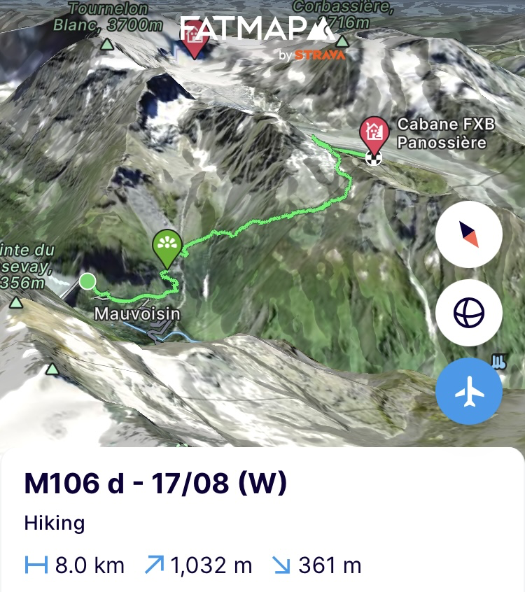
Ik verlaat het hostel dat vroeger een oude atoomschuilkelder was en hou de afstanden voor vandaag en morgen beperkt om flexibel met het weer te kunnen omgaan. De eindhalte vandaag ligt slechts een 8 kilometer en 1000 hoogtemeters verder, de Cabane de Panossière, langs de Tour des Grands Combins. Net zoals de Tour du Cervin en de Tour du Mont Blanc, een notoire huttentocht die rond de Grands Combins door Italië en Zwitserland loopt. De wolken hangen laag en laten het nu en dan eens goed miezeren. Veel zie ik dus niet en in geen tijd ben ik nat van kop tot teen.
Van aan de Lac de Mauvoisin waar de vorige etappe eindigde is het aan één stuk klimmen tot aan de Col des Otanes (2864m). Vanaf 10u stap ik stevig door om zeker voor 2u in de namiddag aan de hut te zijn want dan komt er onweer aan. Ook al zijn de spieren verzuurd, ze werken toch goed mee. Eens ik aan de col begin, laten ze zich voelen. Gelukkig is het nu enkel nog bergaf tot aan de hut. Vanop de col heb ik een prachtig zicht op de Glacier de Corbassière. Een mastodont van een gletsjer die bovenaan afgesneden wordt door de wolken die gelukkig de drie geplande toppen verstoppen. Met het zuur in de benen zou dat zicht het nog zuurder maken. Als ik in de afdaling de morene van de gletsjer opdraai, stoot ik op een kudde van wel 15 steenbokken die in alle rust op de morene gevleid liggen. Slechts enkele schieten op, de andere laten me gemakkelijk tot op vijf meter naderen. Ik laat ze rustig hun ding doen en zet door naar de hut. 2,5 uur gewandeld. Laat het nu maar regenen en bliksemen.
https://fatmap.com/adventureid/151664462/m106-d-17-08-w
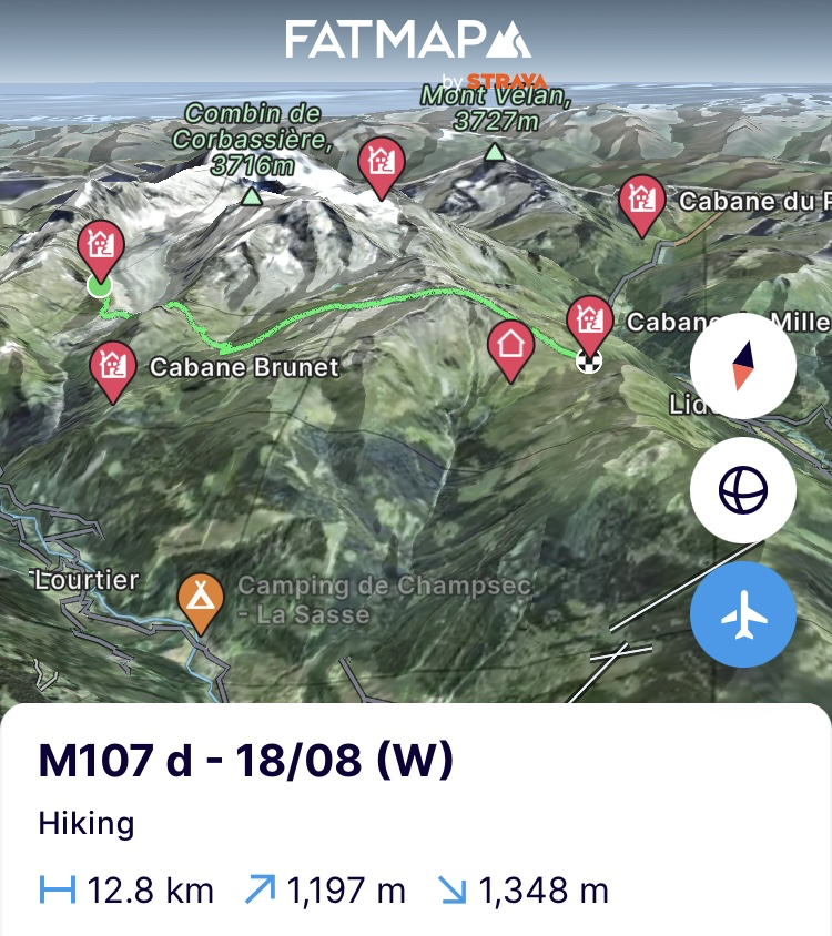
(Zondag 18/08) Vroeg eruit om 5u30 om zeker het slechte weer voor te blijven. Er worden vooral vandaag zware onweersbuien verwacht in de Alpen. In de krant bij het ontbijt, staat de zoveelste ramp door het noodweer. In Tirol in Sankt Anton am Arlberg is een deel van de Arlbergpas weggespoeld en zijn een aantal auto’s door de hevige regenval en modderstromen meegesleurd. Deze frequentere weersextremen zijn deels te wijten aan de klimaatverandering. Voor elke graad Celsius stijging in temperatuur kan de lucht ongeveer 7% meer waterdamp bevatten en dat leidt tot frequentere en zwaardere neerslag. Dat geeft dan weer meer overstromingen en modderstromen
De huttenwirt loopt er een beetje kribbig bij omdat hij zo vroeg moest opstaan om het ontbijt klaar te zetten voor één man, ik dus, die enkel zal doorsteken naar de volgende hut, de Cabane de Mille. Als ik hem vertel dat ik dat zal doen via de Mont Rogneux (3084m) en niet via het normale pad van de Tour des Combins, draait ie al snel bij. Hoewel de Tour des Combins een zeer mooie route is, blijf ik vasthouden aan de filosofie van mijn tocht, zo hoog mogelijk blijven. En dat betekent dus iets meer hoogtemeters maar meer recht op recht richting de eindhalte over de Mont Rogneux.
Om 6u45 ben ik de deur uit. Langs de morene een stukje naar beneden, over de 80 meter lange hangbrug aan de gletsjertong en richting de Col des Avouillons (2649m) de volgende vallei in. Nog een laatste blik vanuit de pas op de Corbassière gletsjer die zich ondertussen heeft kunnen ontdoen van de wolken. Ik zie voor het eerst 2 van de 3 Combins en hun zwaar besneeuwde toppen in de ochtendzon. In de vallei achter de pas proberen de wolken te stijgen tegen de bergflanken en hen in te pakken zoals een rookkanon een artiest op een podium. Als ik de afslag richting Mont Rogneux neem, slagen ze er ook even in om mij volledig in te pakken en besprenkelen ze me met miezerregen.. Iets vroeger dan verwacht en hopelijk voor niet te lang. Gelukkig moeten ze later, als ik me via de rotsgraat een weg baan naar de top, hun greep even lossen. Maar niet voor lang want op de top hullen ze alles in een dichte mist. Kleine pauze en ik daal snel af richting de hut. Het zweet heeft alles onder de hardshell goed klam gekregen en de kou kruipt op mijn lijf. In looppas gaat het dus richting de hut om er snel op te warmen en binnen te zijn voor de regenbuien.
https://fatmap.com/adventureid/151952909/m107-d-18-08-w)
(Maandag 19/08) Om 5u30 ben ik klaarwakker. Het alpiene ritme zit er nog goed in. Nog 2u wachten tot het ontbijt, dus tijd zat om beneden de rugzak al klaar te maken. De hut is gehuld in een dichte mist en volgens de weerradar zal dat zo blijven tot 8u. Om 7u begin ik dus aan een mistige tocht langs de flanken van de Val d’entremont. Het heeft absoluut iets magisch.
De vallei is bekend voor het feit dat een stuk van de Tour des Combins erdoor loopt, maar ook de Muur van Hannibal. Een reeks versterkingen die door de Romeinen gebouwd werden op de passen en in de bergflank vele jaren nadat Hannibal er met zijn leger en olifanten zou zijn doorgetrokken. Voor dat laatste is er echter weinig archeologisch bewijs. Men gokt vandaag nog steeds op 3 mogelijke routes waarvan deze er één is. Lokaal heeft men er alsnog de benaming de Muur van Hannibal aan gegeven. Het doet me denken aan die keer toen ik mijn oudste petekind wijs maakte dat mijn tocht een missie was om de verloren olifanten van Hannibal terug te vinden en te vangen. Als ik verderop het gerinkel van koeienbellen hoor in de dichte mist en een beetje later een paar silhouetten kan onderscheiden, neem ik snel een foto en stuur die op naar zijn moeder. “Zeg hem maar dat ik ze op het spoor ben”.
De etappe van de Tour de Combins daalt helemaal af tot in Bourg Saint Pierre en ik val er het lokale tankstation binnen voor suikers. Het tankstation draagt de naam Le bivouac de Napoleon. Een praatje met de eigenares leert me dat naast Hannibal en Karel de Grote ook Napoleon hier met zijn leger is doorgetrokken en enkele dagen halt gehouden heeft. De inwoners hebben er toen het leger voorzien van eten en drank en Napoleon had beloofd hen er rijkelijk voor te compenseren. Dat laatste deed ie echter nooit en het was uiteindelijk Francois Mitterrand die zovele jaren later met een symbolische euro de langdurige schuld afloste. Inflatie noemen ze dat dan.
Het dorp is er alvast niet beter van geworden en ligt er een beetje mistroostig bij. Deze veldheer kruipt langs de bergflank terug omhoog. Een pittige 800 hoogtemeters die in één keer voor de bijl gaan. Voor de Col de Grand Saint Bernard (2469m) waar de legers moeten zijn doorgetrokken en waarnaar de gelijknamige honden zijn genoemd, steek ik de vallei over en verlaat de Tour des Combins om door te steken richting Tour du Mont Blanc enkele valleien verder.
De berghonden werden vroeger door de monniken van het Saint Bernard klooster gebruikt om verloren gelopen wandelaars op te sporen. Zo kregen ze hun naam. Maar geen hond te zien hier. Als ik even rust voordat ik aan de laatste klim richting de Col du Bastillon (2754m) begin, komt een marmot naast me zitten, als was het een hond die komt vragen om gestreeld te worden. Toch wat hondenmanieren hier. Niet veel later schrikt het beestje op door een horde West Vlaamse bergwandelaars die het pad komen afdonderen. Ze zijn duidelijk op tocht met het KBF (Belgische Klim- en Bergsportfederatie) want ik herken de blauwe t-shirts en logo’s. Ik houd het bij een simpele ‘bonjour’. Het mooie als je alleen onderweg bent is dat je zelf bepaalt wanneer en met wie je praat. Vandaag niet zoveel zin in.
De klim gaat aan een lager tempo. Er zitten al 20km en een 1000-tal hoogtemeters in de benen en ze beginnen er het hunne van te denken. Voor de col ligt mijn eindpunt en hoewel de benen hun cadans blijven houden, wegen ze als lood. Ze moeten nog even volhouden want het water is zo goed als op en ik loop permanent tussen de koeienvlaaien. Om deftig water te vinden, moet ik dus hogerop. Ik spendeer morgen mijn tijd liever op het pad dan voortdurend gehurkt in de struiken. Aan de koeienvlaaien komt echter geen eind, dus geef ik het op. Aan een klein meertje voor de col zet ik de tent nog eens op. Ik heb moeite om me te herinneren wanneer de laatste keer was dat ik ze opzette. Door alle alpiene routes van de laatste weken, verbleef ik enkel in hutten want je mag bijna nergens kamperen en het gewicht van de tent is dus overbodig.
Het meertje wordt gevoed door een stroom over de rotsen en daar zal ik wel deftig water vinden ver weg van de koeienvlaaien, in de rotsen waar de beesten niet geraken. Het is nog een propere klim om er te geraken. Als ik aan de stroom kom, is het eerste wat me opvalt een geweldige vlaai. Het moet een super alpiene koe zijn geweest die hier geraakt is en veel hoger zal ze wel niet geraakt zijn. Ik tank alles vol en loop terug richting tent om te koken en snel het bed in te kruipen.
https://fatmap.com/adventureid/152604835/m108-d-19-08-w
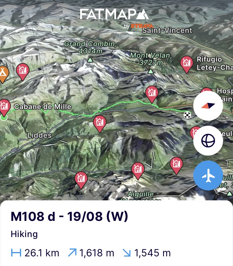
(Dinsdag 20/08) Het was me het nachtje wel. Ik moet me weer aanpassen aan slapen in de tent. Maar om 6u gaat de wekker en word ik beloond met een geweldige zonsopgang. Ontbijten en terug het kampeerritueel zoeken. De tent is nog nat van de dauw, dus laat ik ze zo lang mogelijk in de eerste zon drogen. De rest van de spullen komen her en der verspreid te liggen rond de tent. Het ritueel van opruimen is nog een beetje zoek maar vandaag doen we het op ons gemak. Om 8u ben ik erin geslaagd om het toch allemaal weer proper in de rugzak te stoppen en begin ik aan de laatste hoogtemeters naar de Col de Bastillon. Ze gaan moeizaam en het is duidelijk dat de benen er niet al te veel zin in hebben vandaag.
Als ik bijna in de col ben, laat het majestueuze Mont Blanc massief zich bij elke pas omhoog iets meer zien. De vallei achter de pas is een pareltje met vooral de Lacs des Fenetres die prominent in het landschap liggen. Ze trekken dan ook vele kampeerders aan, merk ik aan de vele tenten die rond het meer staan. Ik moet aan de andere kant van de vallei zijn om door te steken richting Italië. In de afdaling kan ik verderop de Tour du Mont Blanc al zien. Op het pad tekenen zich verscheidene treintjes aan bergtoeristen af. De tocht rond de Mont Blanc door Italië, Zwitserland en Frankrijk slikt jaarlijks maar liefst een 70.000-tal bezoekers. Iets te platgetreden voor mij en geen zin in de drukte. Morgen pas zal ik er een stuk van doen op de laatste kilometers richting Courmayeur. Nu kruip ik langs een oud smokkelpad een vallei verder in om via de Col du Ban Darrey (2694m) Zwitserland achter me te laten.
Er ligt geen officieel aaneengesloten pad tot aan de col, dus is het wat behelpen met de vele sporen die de koeien achterlieten. Het tempo gaat tergend traag. De benen sputteren tegen na de bewogen nacht. Als ik een helikopter een dode koe aan haar achterste poten de vallei zie uitvliegen, hoop ik dat het geen voorteken is. Traag maar gestaag geraak ik tot in de col die pal op de grens van Italië en Zwitserland ligt. Achter me tekenen de Grands Combins zich af en voor mij ligt de Mont Blanc ingepakt in de wolken. 2 maanden heb ik door mijn favoriete Alpenland getrokken en er nog een hoop open rekeningen achter gelaten qua beklimmingen. Het was zoals steeds geweldig mooi, intens en de moeite waard. Maar financieel ook een aderlating. Ik ben dus niet rouwig om goedkopere oorden op te zoeken. Ik kom sowieso terug als de portemonnee terug vol is.
Normaal liep mijn route hier naar beneden richting Tour du Mont Blanc maar blijkbaar kan ik de grens nog even volgen door hoger de graat op te kruipen richting de Colletto (2826m). Bizar dat ik dat in de planning niet zag maar de filosofie is wat ze is en dus hoger de graat op. In de col zou er een pad naar beneden moeten lopen naar een totaal verlaten vallei. Het doet me weer beseffen dat ik in Italië ben en de paden niet altijd geweldig zijn aangeduid. Met de gps in de hand baan ik me een weg naar beneden. Lager in de vallei begin ik een slaapplek te zoeken. Het is nog maar 14u maar de zon schijnt, er is geen mens in de buurt en de benen krijgen hun rust. Tijd om de tent ook te laten drogen, in het gras wat te zonnen en morgen de laatste kilometers naar Courmayeur aan te vatten.
https://fatmap.com/adventureid/152604853/m109-20-08-w
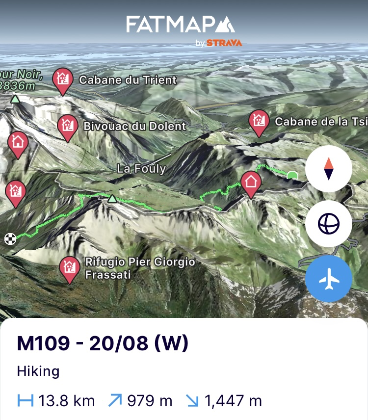
(Woensdag 21/08) Het ochtendritueel heb ik terug onder de knie. Om 6u de wekker, havermoutpot leeg eten die al klaar stond van de avond ervoor, alles proper in de zakjes en tent uit. Op een uur tijd is alles gefikst en hangt de rugzak weer gevuld op de rug. Klaar voor de laatste dag van deze etappe met als eindhalte Courmayeur aan de voet van de Mont Blanc. Ik ga met de gps terug op zoek naar het pad en als die me zegt dat ik aan de overkant van de rivier moet zijn, begin ik aan een prachtig pad alsof het door de steenbokken zelf is aangelegd. De Sentiero o Belle Combe loopt tegen de steile flank van de canyon waar de vallei in uitkomt. Vaak niet breder dan twee schoenen en plakkend tegen de steile bergflank. Een paar kilometers genot alvorens op de Tour du Mont Blanc uit te komen.
Ik draai links de vallei in en loop parallel met de imposante granieten graat van het Mont Blanc massief. Achtereenvolgend klim je er van de ene 4000’er naar de volgende; les Grandes Jorasses, Dome du Rochefort, Dent du Géant, Mont Blanc du Tacul, Mont Maudit en uiteindelijk strandt je oog op de Mont Blanc zelf. Qua traverse de droom van een alpinist. Spijtig genoeg liggen sommige stukken zoals Le Grandes Jorasses er al redelijk droog bij en is ze beklimmen een garantie op steenval. Maar dat is voer voor de volgende etappe.
Ik trek door op de Tour du Mont Blanc die hier een zeer licht hoogteprofiel kent en bijna heel de tijd op hoogte blijft tot ze naar beneden duikt richting Courmayeur. Op het pad is het al goed druk. Ik loop tegen de stroom in en kruis voortdurend vroege wandelaars en lopers. Bonjour, Caio, Hello, Konishiwa, … Zoveel bezoekers, zoveel talen. Het is aan het pad te merken hoeveel volk de tour moet slikken elk jaar. De randen van het pad zijn geperforeerd door de wandelstokken. De grond is dor en platgetreden en spijtig genoeg kom je er ook wel wat afval tegen. Gecommercialiseerd bergtoerisme waar ik het zuur van krijg.
In de berghutten onderweg stop ik voor wat suikers. Verder doe ik de 18km richting Courmayeur op mijn dooie gemak. Niet veel hoogteprofiel, dus rustig de etappe uitlopen. Aan de Rifugio Bertoni begin ik de regelrechte afdaling naar Courmayeur. De spirit zit goed en hoewel ik nog steeds met zwaardere bergschoenen rondloop, willen de benen de trailrun vaardigheden ervan eens testen. Ik schiet naar beneden tegen de richting in van de stroom aan bergtoeristen die naar boven sjokken. Velen zijn veel te zwaar beladen en hangen over hun stokken in de steile klim. Zwaar gespierde fitness kerels die snakken naar adem. Meisjes met rugzakken die groter zijn dan henzelf. Aziaten die ingepakt rondlopen alsof ze onderweg zijn naar Everest basecamp. Het is me een zicht. Ik hoop dat ze er ten volle van genieten. Ik in elk geval en nog steeds. In Courmayeur val ik de superette binnen voor alles wat vettig is en ik gemist heb en dan…
https://fatmap.com/adventureid/152604865/m110-1-21-08-w
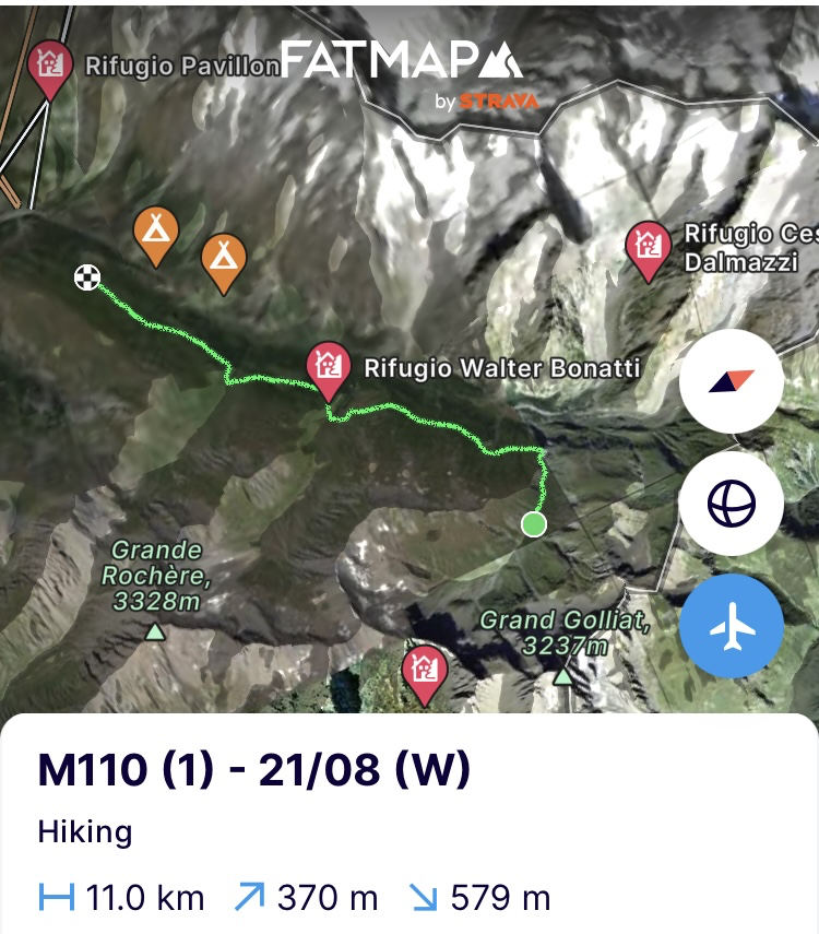
Op naar Monaco!
Bergse groeten en tot snel!
————— ENGLISH VERSION —————
(Saturday 17/08) I have been sitting on my ass for too long. The bad weather, a climbing partner who is on the sickbed and the uncertainty about whether a guide would be able to take me, have held me hostage since Tuesday. Finally, the guides did not feel like taking me on the planned route given the expected conditions on Les Grands Combins. The more common crossing of these three 4000-meter peaks runs from west to east, although the reverse is also possible but slightly more challenging. Yesterday the decision was made and although today and tomorrow still have bad weather, I have a hard time sitting on my butt and I can feel the lactic acid creeping into my muscles. So I'll just push forward based on the weather radar for two days and try to navigate between the rain showers. Those peaks are not going away and I will definitely come back to finish them.
I leave the hostel that used to be an old nuclear shelter and keep the distances for today and tomorrow limited in order to be able to deal flexibly with the weather. Today's final stop is only 8 kilometres and 1000 metres of elevation gain away, the Cabane de Panossière, along the Tour des Grands Combins. Just like the Tour du Cervin and the Tour du Mont Blanc, a notorious mountain hut tour that runs around the Grands Combins through Italy and Switzerland. The clouds hang low and occasionally let it drizzle heavily. So I don't see much and in no time I am soaked from head to toe.
From the Lac de Mauvoisin where the previous stage ended, it is a continuous climb to the Col des Otanes (2864m). I start at 10am at a speedy pace to be definitely at the hut before 2pm, as a thunderstorm is approaching. Despite the fact that my muscles are sore, they still cooperate well. Once at the pass, however, they start to think differently about it. Fortunately, it is only downhill to the hut from here. From the pass, a beautiful view of the Glacier de Corbassière is visible. A giant glacier that is cut off at the top by the clouds that fortunately hide the three planned summits. With the acid in my legs, this would only have become more acidic. When I turn onto the moraine of the glacier on the descent, I come across a herd of at least 15 ibexes that lie peacefully on the moraine. Only a few hurry up and the others easily let me approach them to within five meters. I let them do their thing and continue to the hut. Done it in 2.5 hours of hiking. Now it can rain and shed lightning. (https://fatmap.com/adventureid/151664462/m106-d-17-08-w)
(Sunday 18/08) Up early at 5:30 to definitely stay ahead of the bad weather. Heavy thunderstorms are expected in the Alps, especially today. When I read the newspaper over my breakfast, it contains yet another disaster due to the bad weather. In Tyrol in Sankt Anton am Arlberg, part of the Arlberg Pass has been washed away and a number of cars have been swept away by the heavy rainfall and mudflows. These more frequent weather extremes are partly due to climate change, as for every degree Celsius increase in temperature, the air can hold about 7% more water vapour, which leads to more frequent and heavier precipitation. This in turn leads to more flooding and mudflows.
The hut owner is already a bit grumpy because he had to get up so early to prepare breakfast for just me. When I tell him that I will be crossing via Mont Rogneux (3084m) and not via the normal route of the Tour des Combins, he quickly changes his mind. Although the Tour des Combins is a very beautiful route, I continue to stick to the philosophy of my tour, to stay as high up as possible. And that means a bit more altitude but more straight ahead towards the Canne de Mille, the final stop on the otherside of the Mont Rogneux.
At 6:45 I'm out the door. Along the moraine a bit down, over the 80 meter long suspension bridge at the glacier tongue and towards the Col des Avouillons (2649m) into the next valley. One last look from the pass at the Corbassière glacier that has managed to get rid of the clouds in the meantime and so also for the first time 2 of the 3 Combins expose their heavily snow-covered peaks in the morning sun. In the valley behind the pass the clouds try to rise against the mountainsides and wrap them up like a smoke cannon wraps up an artist on a stage. When I take the path towards Mont Rogneux, they also manage to wrap me up completely and sprinkle me with the drizzle they release. A bit earlier than expected and hopefully not for too long. Fortunately, they have to let go of their grip later when I make my way up the rock ridge to the top. But not for long because at the top they wrap everything in a thick mist. A short break and I quickly descend towards the hut. The sweat has made everything under the hardshell really clammy and the cold is creeping up on my body. So I descend at a high pace towards the hut to warm up quickly and be inside before the rain showers start. (https://fatmap.com/adventureid/151952909/m107-d-18-08-w)
(Monday 19/08) At 5:30am my eyes open up and I am wide awake. The alpine route rhythm is still going strong. I still have 2 hours to wait until breakfast, so there is plenty of time to get my backpack ready downstairs. The hut is shrouded in a thick fog and according to the weather radar it will stay that way until 8 am. So at 7 am I start a misty hike along the flanks of the Val d’entremont. It definitely has something magical.
In addition to the fact that a section of the Tour des Combins runs through it, the valley is also known for Hannibal’s Wall. A series of fortifications that were built by the Romans on the passes and in the mountainside many years after Hannibal had passed through with his army and elephants. Then again, there is little archaeological evidence for the latter and today scientists still bet on 3 possible routes, of which this is one. However, it has been given the local name Hannibal's Wall. It reminds me of when I told my eldest godchild that me crossing the Alps was a mission to find and capture Hannibal's lost elephants. When I hear the tinkling of cowbells in the thick fog further on and I can make out a few silhouettes a little later, I quickly take a photo and send it to his mother. "Tell him I'm chasing them down and almost have them".
The stage of the Tour de Combins descends all the way to Bourg Saint Pierre and I drop into the local gas station for sugar. The gas station is called Le bivouac de Napoleon. A chat with the owner tells me that in addition to Hannibal and Charlemagne, Napoleon also passed through here with his army and stopped for a few days in Bourg Saint Pierre. The inhabitants provided the army with food and drinks and Napoleon had promised to compensate them generously for it. However, he never did the latter and it was ultimately Francois Mitterrand who paid off the long-term debt with a symbolic euro so many years later. Inflation, this is called.
The village has certainly not improved and looks a bit gloomy. This general crawls back up the mountainside. A tough 800 metres in elevation gain which are done in one go. Before the Col de Grand Saint Bernard (2469m) where the armies must have passed through and after which the dogs of the same name are named, I cross the valley and leave the Tour des Combins to continue towards the Tour du Mont Blanc a few valleys further.
The Saint Bernard mountain dogs were used in the past by the monks of the Saint Bernard monastery to track down lost hikers and that is how they got their name. No dog to be seen here and when I rest for a moment before starting the last climb towards the Col du Bastillon (2754m), a marmot comes to sit next to me as if it were a dog asking to be stroked. Still some dog manners here. Not much later she is startled by a horde of West Flemish mountain hikers who come thundering down the path. They are clearly on a trip with the KBF (Belgian Climbing and Mountaineering Federation) because I recognize the blue t-shirts and logos. However, I stick to a simple 'bonjour'. The nice thing about being on your own is that you decide when and with whom you talk. And today I don't feel like it.
I climb at a slower pace. There are already 20 km and about 1000 meters of elevation gain in the legs and they are starting to have their own idea about it. My destination is before the pass and although my legs keep up their rhythm, they still weigh like lead. They have to hold on for a while because the water is almost gone and I am constantly walking between the drops of cow shit (‘cowpats’). In order to find decent water, I have to go higher up. After all, tomorrow I would rather spend my time on the path than constantly crouching in the bushes. However, the cowpats never seem to end so I give up. At a small lake before the pass I pitch the tent. It occurs to me that I have trouble remembering the last time I pitched it. Because of all the alpine routes of the last few weeks, I only stayed in mountain huts because you are hardly allowed to camp anywhere and the weight of the tent is therefore unnecessary.
The lake is fed by a stream over the rocks and there I will find decent water far away from the cowpats and in the rocks where the animals cannot reach. It is still a nice climb to get there and when I reach the stream, the first thing I notice is a great cowpat. This must have been a super alpine cow to get here and she probably couldn't have gotten much higher. I fill up the tank a bit higher up and walk back to the tent to cook and quickly crawl into bed. (https://fatmap.com/adventureid/152604835/m108-d-19-08-w)
(Tuesday 20/08) It was quite a night and clearly adjusting back to sleeping in the tent. Nevertheless, the alarm goes off at 6am and I am rewarded with a great sunrise. Breakfast and back to the camping ritual. The tent is still wet from the morning dew so I let it dry in the first sun as long as possible. The rest of the stuff ends up scattered around the tent. The ritual of tidying up is still a bit lost but today I take it easy. At 8 o'clock I managed to get everything back in the backpack and I start the last meters of elevation gain to the Col de Bastillon. They are acting difficult and it is clear that my legs are not really in the mood for it today.
When I am almost at the pass, the majestic Mont Blanc massif shows itself a little more with every pass up. The valley behind the pass is a gem with especially the Lacs des Fenetres that are prominent in the landscape. They attract many campers, as can be seen from all the tents that are around the lake. I have to be on the other side of the valley to continue towards Italy. On the descent I can already see the Tour du Mont Blanc further on. Several trains of mountain tourists are visible on the path. The tour around Mont Blanc through Italy, Switzerland and France attracts no less than 70,000 visitors each year. A bit too well-trodden for me and I don't feel like the crowded feel of it. I will only do a part of it tomorrow on the last kilometres towards Courmayeur. Now I crawl along an old smuggling path further into a valley to leave Switzerland behind me via the Col du Ban Darrey (2694m).
There is no official continuous path up to the pass so I have to do it with the many tracks left by the cows. The pace is excruciatingly slow. My legs are struggling today after the eventful night. When I see a helicopter flying a dead cow out of the valley by its hind legs, I hope that it is not an omen. Slowly but steadily I reach the pass that lies right on the border of Italy and Switzerland. Behind me the Grands Combins are visible and in front of me lies Mont Blanc wrapped in the clouds. I have been travelling through my favourite Alpine country for 2 months and have left a lot of open accounts in terms of climbs. It was, as always, incredibly beautiful, intense and worth it. But also a cash drain so I am not sad to look for cheaper places. I will definitely come back when my wallet is fat and full again.
Normally my route here went down towards Tour du Mont Blanc but apparently I can still follow the border by crawling higher up the ridge towards the Colletto (2826m). It is bizarre that I did not see this in the planning but the philosophy is what it is and so I continue higher up the ridge. In the pass there should be a path down to a completely deserted valley. When I have a hard time finding it, this reminds me that I am in Italy again and the paths are not always very well marked, just like this one. With the GPS in hand it is therefore a matter of making a way down. Lower down in the valley I start looking for a place to sleep. It is only 2 pm but the sun is shining, no one is around and my legs are getting their deserved rest. Time to let the tent dry, sunbathe in the grass and tackle the last kilometres to Courmayeur tomorrow. (https://fatmap.com/adventureid/152604853/m109-20-08-w)
(Wednesday 21/08) I have mastered the ritual again. Alarm at 6am. Eat the oatmeal jar that was ready the night before. Everything neatly in the bags and out of the tent. In an hour everything is fixed and the backpack is hanging well structured on my back again. Ready for the last day of this stage with Courmayeur as the final stop at the foot of Mont Blanc. I go back with the GPS to look for the path and when it tells me that I have to be on the other side of the river, I start on a beautiful path as if it was laid out by the ibexes themselves. The Sentiero o Belle Combe runs against the steep flank of the canyon where the valley ends. Often no wider than two shoes wide and sticking to the steep mountainside. A few kilometres of path pleasure before reaching the Tour du Mont Blanc.
I turn left into the valley and walk parallel to the imposing granite ridge of the Mont Blanc massif. You can climb from one 4000-metre peak to the next; les Grandes Jorasses, Dome du Rochefort, Dent du Géant, Mont Blanc du Tacul, Mont Maudit and finally your eye lands on the Mont Blanc itself. A mountaineer's dream in terms of traverse. Unfortunately, some parts such as Les Grandes Jorasses are already quite dry and climbing them is a guarantee of rockfall. But that is food for the next stage.
I continue on the Tour du Mont Blanc which has a very light elevation profile here and stays at altitude almost the entire time until it dives down towards Courmayeur. It is already very busy on the path and since I am walking against the current, I am constantly crossing early walkers and runners. Bonjour, Caio, Hello, Konishiwa, … Every greeting is addressed because of the large mix of visitors. The path also shows how many visitors the tour has to swallow each year. You walk between the perforated edges of it as a result of the many walking sticks. The ground is dry and flattened and unfortunately I also come across more waste than I am used to. A piece of commercialized mountain tourism that makes me feel sour.
In the mountain huts along the way I stop for some sugars. Not much elevation profile so I finish the last 18km and the stage calmly. At the Rifugio Bertoni I start the straight descent to Courmayeur. The spirit is good and although I still walk around with heavier mountain boots, my legs want to test their trail running skills. I shoot down against the direction of the train of mountain tourists who are trudging up. Many of them far too heavily loaded and hanging over their poles in the steep climb. Heavily muscled fitness guys who gasp for breath. Girls with backpacks that are bigger than themselves. Asians who walk around bundled up as if they are on their way to Everest base camp. It is an odd sight to me but I do not care. I hope they enjoy it to the fullest. I certainly do and still do. In Courmayeur I pop into the supermarket for everything that is missed and greasy and then… (https://fatmap.com/adventureid/152604865/m110-1-21-08-w)
Off to Monaco!Mountain greetings and see you soon!
